Stamford to Oakham
![]()
![]() This ride follows National Cycle Route 63 from Lincolnshire into Rutland. You start in Stamford town centre heading west towards Exton on country roads. A lovely spell along Rutland Water takes you into the finish point in Oakham.
This ride follows National Cycle Route 63 from Lincolnshire into Rutland. You start in Stamford town centre heading west towards Exton on country roads. A lovely spell along Rutland Water takes you into the finish point in Oakham.
Stamford to Oakham Ordnance Survey Map  - view and print off detailed OS map
Stamford to Oakham Open Street Map  - view and print off detailed map
Stamford to Oakham OS Map  - Mobile GPS OS Map with Location tracking
Stamford to Oakham Open Street Map  - Mobile GPS Map with Location tracking
Pubs/Cafes
The Harbour Cafe is in a lovely spot overlooking Whitwell Harbour on Rutland Water. It's a great place to stop on the route and rest your legs. The cafe is open 7 days a week from March until November then they open Friday, Saturday and Sunday through the Winter. They offer a wide variety of, cooked breakfasts, home cooked lunches, snacks, great coffee and cakes in a relaxed family friendly environment. There's a great outdoor seating area with fine views of the water. You can find the cafe on Bull Brigg Lane with a postcode of LE15 8BL for your sat navs.
Cycle Routes and Walking Routes Nearby
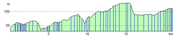
Elevation Profile