Stockport to Glossop
18.6 miles (30 km)
![]()
![]() This route goes from Greater Manchester into Derbyshire via National Cycle Route 62. The route starts by the railway station in Stockport and soon joins the Trans Penine Trail taking you along the River Tame and through Reddish Vale Country Park. You continue off road along the trail until Godley Green where quiet roads take you onto Broadbottom and then Hadfield crossing the River Etherow. A short stretch south then takes you through the High Peak district of Derbyshire with some wonderful scenery before you finish in Glossop at the train station.
This route goes from Greater Manchester into Derbyshire via National Cycle Route 62. The route starts by the railway station in Stockport and soon joins the Trans Penine Trail taking you along the River Tame and through Reddish Vale Country Park. You continue off road along the trail until Godley Green where quiet roads take you onto Broadbottom and then Hadfield crossing the River Etherow. A short stretch south then takes you through the High Peak district of Derbyshire with some wonderful scenery before you finish in Glossop at the train station.
Stockport to Glossop Ordnance Survey Map  - view and print off detailed OS map
Stockport to Glossop Open Street Map  - view and print off detailed map
Stockport to Glossop OS Map  - Mobile GPS OS Map with Location tracking
Stockport to Glossop Open Street Map  - Mobile GPS Map with Location tracking
Cycle Routes and Walking Routes Nearby
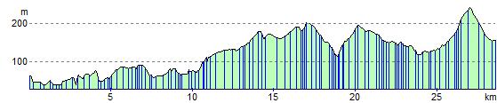
Elevation Profile