Three Downs Link
![]()
![]() This is a walking and cycling path following bridleways through Hampshire, Berkshire, Wiltshire and Oxfordshire. The trail runs from Exton, in Hampshire, to Dean Hill, near Hungerford. You will pass through open chalk downland, along rivers and canals and through some pretty villages.
This is a walking and cycling path following bridleways through Hampshire, Berkshire, Wiltshire and Oxfordshire. The trail runs from Exton, in Hampshire, to Dean Hill, near Hungerford. You will pass through open chalk downland, along rivers and canals and through some pretty villages.
The route passes through or near Basingstoke, New Arlesford, Malborough, Winchester, Newbury and Hungerford.
It uses the South Downs Way National Trail for part of the route and also links with the Ridgeway National Trail.
It is waymarked with a light blue arrow.
For cyclists a mountain bike is advisable as most of the route takes place on off road tracks.
Three Downs Link Ordnance Survey Map  - view and print off detailed OS map
Three Downs Link Open Street Map  - view and print off detailed map
Three Downs Link OS Map  - Mobile GPS OS Map with Location tracking
Three Downs Link Open Street Map  - Mobile GPS Map with Location tracking
Pubs/Cafes
In Newbury you will find the delightful Tea Shop By The Canal which is perfect for afternoon tea. Set in an interesting old Grade II listed building the tea shop blends the comfort and warmth of Italian culture with the fine and splendid rituals of English Cream Teas. There's also outdoor seating so you can sit out right next to the canal on warm summer days. You can find it at The Stone Building, The Wharf, Newbury with a postcode of RG145AS.
Cycle Routes and Walking Routes Nearby
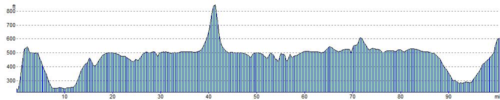
Elevation Profile