Tissington Trail
![]()
![]() The Tissington trail is a 13 mile off road path following the trackbed of a disused railway line through the stunning Peak District National Park.
The Tissington trail is a 13 mile off road path following the trackbed of a disused railway line through the stunning Peak District National Park.
The trail is shared by walkers and cyclists offering fabulous views of the Derbyshire countryside. It runs from Parsley Hay in the north to Ashbourne in the south.
The trail links with the popular High Peak Trail at High Peak Junction.
It's a similar rail trail running from Cromford to Dowlow with more great views.
For more information on this trail, including picnic areas and cycle hire please click here.
Tissington Trail Ordnance Survey Map  - view and print off detailed OS map
Tissington Trail Open Street Map  - view and print off detailed map
Tissington Trail OS Map  - Mobile GPS OS Map with Location tracking
Tissington Trail Open Street Map  - Mobile GPS Map with Location tracking
Pubs/Cafes
The trail passes the village of Fenny Bentley where you could make a pit stop at the Bentley Brook Inn. There's a lovely large garden area where you can relax on warm summer days. You can find them at postcode DE6 1LF for your sat navs. The inn is very dog friendly if you have your four legged friend with you.
The village itself is also worth exploring with the pretty Bentley Brook and a 14th century church to see.
Near Tissington you could take a small detour from the route to visit the worthy village of Parwich where you'll find the noteworthy Sycamore Inn. The limestone inn dates all the way back to the 1600s and is in a lovely spot close to the pretty village green. They serve good quality home cooked food and a fine ranges of ales. You can find them at postcode DE6 1QL for your sat navs. The inn also serves as the village shop so you can pick up various bits and bobs here too.
Further Information and Other Local Ideas
The route passes along part of the epic Pennine Cycleway which can be used to further extend your ride.
Cycle Routes and Walking Routes Nearby
Photos

Tissington Trail, south of Tissington

View south on Tissington Trail

Tissington Trail near Tissington

The Tissington Trail, near Tissington

This view is of a footpath crossing the trail, looking from the stile on one side to the stile on the other.

Looking toward Tissington from the site of Alsop station.

Looking north along the course of the former Ashbourne - Buxton Railway line at Hartington, currently used as a cycleway and long distance footpath.

Here the trail is shown crossing the A515 Ashbourne to Buxton road near Fenny Bentley.
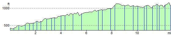
Elevation Profile