Wiltshire Cycleway - Mere to Salisbury
![]()
![]() This is the second section of the Wiltshire Cycleway which runs for 160 miles through some of the most beautiful countryside in the county.
This is the second section of the Wiltshire Cycleway which runs for 160 miles through some of the most beautiful countryside in the county.
This leg starts at Mere and passes along quiet country lanes to Salisbury via the pretty villages of Donhead St Mary, Broad Chalke and Bishopstone.
Highlights include two pleasant riverside runs along the River Ebble and the final stretch along the River Naddar into Salisbury with its magnificent cathedral.
Just before Salisbury you will also pass the impressive Wilton House and Gardens. With magnificent state rooms and beautifully landscaped gardens, Wilton House is a major attraction on this section of the route.
Good access points for this route are the train station at Gillingham in Dorset, near the start of the route, or Salisbury station at the other end.
Wiltshire Cycleway - Mere to Salisbury Ordnance Survey Map  - view and print off detailed OS map
Wiltshire Cycleway - Mere to Salisbury Open Street Map  - view and print off detailed map
*New* - Walks and Cycle Routes Near Me Map - Waymarked Routes and Mountain Bike Trails>>
Wiltshire Cycleway - Mere to Salisbury OS Map  - Mobile GPS OS Map with Location tracking
Wiltshire Cycleway - Mere to Salisbury Open Street Map  - Mobile GPS Map with Location tracking
Cycle Routes and Walking Routes Nearby
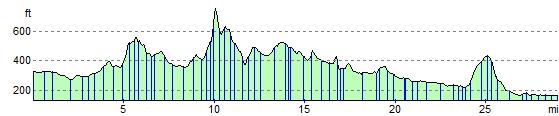
Elevation Profile