Aber Falls Easy Walk
![]()
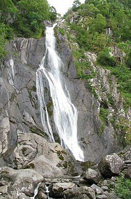
![]() This walk visits the beautiful Aber Falls in the Snowdonia National Park. The falls are one of the walking highlights of the park with nice trails and stunning scenery.
This walk visits the beautiful Aber Falls in the Snowdonia National Park. The falls are one of the walking highlights of the park with nice trails and stunning scenery.
The walk takes you from the car park, just to the south of the village of Abergwyngregyn. You then follow a waymarked footpaths south for a distance of just over 1 mile, before coming to the beautiful falls. There is some climbing involved as the path rises through the nature reserve to the falls. It's a wonderful area with lots of wildlife and fine views of the surrounding mountains. Rhaeadr Fawr, as it is also known, is formed as the Afon Goch plunges about 120 feet (37 m) over a sill of igneous rock.
After taking in the falls you then follow the same path back to the car park. There's a nice picnic area back at the car park where you could relax before heading off.
For a longer, more challenging route see our Aber Falls Circular Walk which follows other footpaths to the west of the falls.
To further extend your walking head north to the coast at Abergwyngregyn. There's a nice footpath here which will take you along Lavan Sands where there's lots of birdlife to look out for.
Postcode
LL33 0LP - Please note: Postcode may be approximate for some rural locationsAber Falls Easy Walk Ordnance Survey Map  - view and print off detailed OS map
Aber Falls Easy Walk Open Street Map  - view and print off detailed map
Aber Falls Easy Walk OS Map  - Mobile GPS OS Map with Location tracking
Aber Falls Easy Walk Open Street Map  - Mobile GPS Map with Location tracking
Pubs/Cafes
The Aber Falls Cafe is a nice choice for some refreshments after your walk. The cafe supplies fine cakes, specialty coffees, toasted panini and luxury champagne high teas. There's a nice bright conservatory and a veranda with a lovely view of the garden. You can find the cafe in Abergwyngregyn with a postcode of LL33 0LD for your sat navs.


