Alport Castles
![]()
![]() This walk visits this extraordinary geological feature in the Peak District National Park. Alport Castles is a spectacular formation of rocks formed from numerous landslides over a period of time. The largest of these, resembles a full-scale motte and bailey castle. It's a fabulous sight and is surrounded by some stunning Peak District scenery. Bird watchers can look out for peregrine falcons nesting on the crags. The elevated spot on the the stepped landslip makes ideal spot for sitting down and soaking up the views.
This walk visits this extraordinary geological feature in the Peak District National Park. Alport Castles is a spectacular formation of rocks formed from numerous landslides over a period of time. The largest of these, resembles a full-scale motte and bailey castle. It's a fabulous sight and is surrounded by some stunning Peak District scenery. Bird watchers can look out for peregrine falcons nesting on the crags. The elevated spot on the the stepped landslip makes ideal spot for sitting down and soaking up the views.
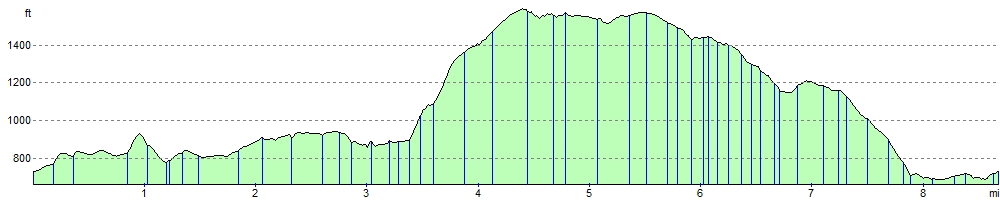
This circular walk starts at the parking area at the northern end of Ladybower Reservoir. You then follow a footpath along Derwent Reservoir and Howden Reservoir, passing through woodland with views of the impressive Howden Dam on the way. The walk then climbs away from the reservoir towards Alport Castles. Here you can enjoy wonderful views over the River Alport and Alport Dale. The walk then descends to Hagg Side woodland before returning to Ladybower Reservoir.
To extend your walking in the are you could try the fantastic climbs to Derwent Edge and Stanage Edge.
Alport Castles Ordnance Survey Map  - view and print off detailed OS map
Alport Castles Open Street Map  - view and print off detailed map
Alport Castles OS Map  - Mobile GPS OS Map with Location tracking
Alport Castles Open Street Map  - Mobile GPS Map with Location tracking
Pubs/Cafes
The Ladybower Inn is a good local choice for some post walk refreshments. This traditional stone-built pub dates back to the 18th century when it served as a Coaching Inn. There's also a nice beer garden with views over the Ladybower reservoir. The pub is located on The Snake Pass, at the eastern end of the lower Ladybower reservoir. Postcode is S33 0AX.
The Fairholmes Visitor Centre at the start of the route also has a refreshment kiosk with nice picnic tables outside. Inside there's a wealth of information on the area including interactive exhibitions for all ages.
Cycle Routes and Walking Routes Nearby
Photos

Alport Castles. A major landslip above the Alport valley.

Looking toward Alport castles

Landslip - Alport Castles A popular spot for lunch, the stepped landslip makes ideal seating!

The Tower, Alport Castles

Alport Castles Farm. Apart from the buildings, this view looks alpine.

Erosion at the site

Waymarker, Alport Castles Path

View over the tower to the surrounding woodland and countryside
Elevation Profile