Derwent Edge Salt Cellar Short Circular Walk
![]()
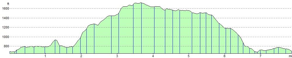
![]() Climb to this wonderful Millstone Grit escarpment and enjoy fabulous views back down to the numerous beautiful reservoirs below. It's a challenging circular walk climbing to a height of over 1700ft around Back Tor. You will be rewarded with stunning far reaching views over the Peak District.
Climb to this wonderful Millstone Grit escarpment and enjoy fabulous views back down to the numerous beautiful reservoirs below. It's a challenging circular walk climbing to a height of over 1700ft around Back Tor. You will be rewarded with stunning far reaching views over the Peak District.
The area is also full of interesting flora and fauna. Look out for rare plants such as common cottongrass, mountain strawberry and crowberry. Wildlife includes Eurasian golden plover, red grouse, ring ouzel and mountain hare.
The walk starts from the Fairholmes car park in between Ladybower Reservoir and Derwent Reservoir. Here you will find a great visitor centre which makes an excellent base for exploring the Derwent Valley.
The trail heads north along Derwent Reservoir towards the impressive Derwent Dam. Just after Abbey Bank you turn east and start the climb to Lost Lad Hill, crossing Little Howden Moor and Greystones Moss. At the summit of Lost Lad there's a toposcope showing the surrounding hills. You can also see up to Back Tor, the next destination on the walk. From here there are fabulous views over the reservoirs below, Stanage Edge and the Kinder Plateau.
From Back Tor you head south to Dovestone Tor and along the fantastic ridge path towards Derwent Edge. Around here there are some wonderful geological formations including the impresive Salt Cellar stone. It has a striking resemblance to a certain condiment holder! Even more impressive are the Wheel Stones (or Coach and Horses) which resemble a coach and horses on the horizon when viewed from the A57 road to the south.
Shortly after passing the Wheel Stones you turn west and descend back to Ladybower Reservoir. The final section takes you along the water back to the car park. The visitor centre has a good cafe where you can refresh yourself after your adventure.
To extend your walking in the area you can follow the waterside trail along Ladybower Reservoir and visit Lower Ladybower Reservoir.
If you are interested in more exhilarating climbs then look no further than Stanage Edge and Bamford Edge which are both nearby. For geology enthusiasts Alport Castles with its spectacular formation of rocks, is a must see.
Derwent Edge Ordnance Survey Map  - view and print off detailed OS map
Derwent Edge Open Street Map  - view and print off detailed map
*New* - Walks and Cycle Routes Near Me Map - Waymarked Routes and Mountain Bike Trails>>
Derwent Edge OS Map  - Mobile GPS OS Map with Location tracking
Derwent Edge Open Street Map  - Mobile GPS Map with Location tracking
Pubs/Cafes
The Ladybower Inn is a good local choice for some post walk refreshments. This traditional stone-built pub dates back to the 18th century when it served as a Coaching Inn. There's also a nice beer garden with views over the Ladybower reservoir. The pub is located on The Snake Pass, at the eastern end of the lower Ladybower reservoir. Postcode is S33 0AX.
The Fairholmes Visitor Centre at the start of the route also has a refreshment kiosk with nice picnic tables outside. Inside there's a wealth of information on the area including interactive exhibitions for all ages.
Cycle Routes and Walking Routes Nearby
Photos

Derwent Edge. The area is notable for its unusual gritstone tors and its glorious views of the the Dark Peak landscape. These features coupled with its proximity to the city of Sheffield have made it a popular site for walkers.
The open moorland and exposed rock faces are punctuated by hardy grasses, patches of heather, and seasonal wildflowers that bring colour and life to the barren terrain. The natural vegetation, well adapted to the harsh conditions, provides essential habitat for small mammals and a variety of bird species that thrive in open, windswept areas.

Derwent Salt Cellar. The most recognisable of the unusually shaped gritstone tors on the edge. These have been formed by the actions of wind, rain and frost over many centuries.
The geology of Derwent Edge is a prime example of millstone grit formations, with layered sedimentary rocks that have been shaped over millions of years by erosion and weathering. The craggy outcrops and steep cliffs reveal the ancient processes that formed the Peak District, making the edge not only a visual marvel but also a significant geological landmark.

White Tor on Derwent Edge. Looking south to the A57 bridge over Ladybower Reservoir.
The views from Derwent Edge are nothing short of dramatic, offering panoramic vistas of rolling moorlands, deep valleys, and distant peaks that define the Peak District's character. Walkers can expect to see kestrels and buzzards soaring overhead, and species such as skylarks and meadow pipits flitting among the heather. Small mammals like rabbits and voles make their home in the undergrowth, and an array of butterflies and dragonflies add lively movement to the scenery.

Footpath Along Derwent Edge Looking south from near Back Tor. Notable points seen from here are Cakes of Bread, Dovestone Tor, Salt Cellar, White Tor and the Wheelstones.

View Southwest from Whinstone Lee Edge. The popularity of the area has led to some footpath erosion. Some of the most affected parts of the edge between The Salt Cellar and Lost Lad Hillend have been paved with natural stone slabs to reduce further damage as part of the Lottery Paths Project.

Derwent Edge highway with pretty heather in late summer. Much of the moorland has been designated as a Site of Special Scientific Interest (SSSI) because of its special vegetation and rare birds and animals. These include the Eurasian golden plover, red grouse, ring ouzel and mountain hare. Rare species of plants such as common cottongrass, mountain strawberry, and crowberry grow in the area.

Northeast view from Dovestone Tor

Back Tor, the summit rocks from the south. An Ordnance Survey column marks the highest point of the Edge at Back Tor (538 metres, 1765 feet). Just north of here the edge extends into Howden Edge and enters the county of South Yorkshire.
Elevation Profile