Ben Ledi Walk
![]()
![]() Climb to this popular viewpoint on this challenging walk in the Trossachs. The mountain gives fabulous views over the woodland and lochs of the Queen Elizabeth Forest Park.
Climb to this popular viewpoint on this challenging walk in the Trossachs. The mountain gives fabulous views over the woodland and lochs of the Queen Elizabeth Forest Park.
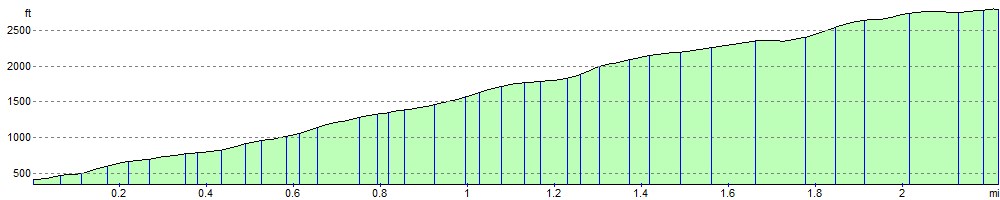
There's a car park at Creag Dhubh, just off the A84, about 2 miles west of Callander. From here you can pick up the tracks to take you through woodland and then up on to the mountain peak. It's about a 2.5 climb from the car park to the 879 m (2,884 ft) summit of Ben Ledi. There's fabulous views of Loch Lubnaig and Callander, while on a clear day you can see as far as the Wallace Monument and Stirling Castle. There's also splendid views of some of the most famous mountains of the area including Ben Lawers and Ben Lomond.
To extend your exercise in the area you could enjoy a waterside cycle or walk along Loch Lubnaig and visit the delightful Falls of Leny on the way. The Rob Roy Way also passes through the area so you could futher explore the Queen Elizabeth Forest Park by picking up the trail and visiting Loch Venachar and Loch Drunkie.
Ben Ledi Ordnance Survey Map  - view and print off detailed OS map
Ben Ledi Open Street Map  - view and print off detailed map
*New* - Walks and Cycle Routes Near Me Map - Waymarked Routes and Mountain Bike Trails>>
Ben Ledi OS Map  - Mobile GPS OS Map with Location tracking
Ben Ledi Open Street Map  - Mobile GPS Map with Location tracking
Cycle Routes and Walking Routes Nearby
Photos

Taken from the lower slopes of Ben Ledi looking down to Loch Lubnaig. The mountain’s name is derived from the Gaelic "Beinn Ledidh," meaning "hill of the blind," which is thought to reference the mountain's distinctive shape when viewed from the south.
Climbing Ben Ledi offers an excellent opportunity to explore diverse flora and fauna in the Trossachs region. The lower slopes are mainly covered by woodlands, where broadleaf and coniferous trees dominate, alongside vibrant undergrowth. As you ascend, the landscape transitions into heath and bog habitats, which are home to a variety of wildlife.

North Ridge. In terms of flora, expect to see swathes of purple heather and yellow gorse, especially during the spring and summer months. These plants are prominent in the lower valleys and on the moorland areas, adding splashes of colour to the landscape. Various wildflowers dot the hillside as well, and the scents of these blossoms permeate the air during warmer seasons.

Summit Trig. Looking ESE towards the Ochil Hills.
For fauna, the area is a haven for birdlife. Buzzards are often seen soaring above, hunting in the open spaces, while golden eagles may also be spotted in the higher, more remote areas. Ben Ledi is home to mammals like red deer, which are commonly seen grazing in the more secluded areas. Red squirrels can occasionally be spotted in the trees, though they are more elusive. The region also offers ample opportunities to observe smaller wildlife, such as mountain hares and a variety of insect species that thrive in the heath and bog environments.

Above the Tree Line. This is on the main track from Stank to the summit of Ben Ledi. Foxgloves grow amongst the heather on the grassy hillside just above the coniferous plantation.

Memorial Cross

Here we are looking down the path which leads up to the summit of Ben Ledi. This is not far from the point where the path turns to make the final ascent. Some of the mountains on the far side of Loch Lubnaig can also be seen in the background.
For safety, it's important to check the weather forecast before attempting the climb, as the conditions can change rapidly in this part of Scotland. Winter weather, in particular, can bring snow and ice, making the climb more challenging.

Path on the lower slopes. This is the point where the path emerges from the forest and crosses a forest track. The map indicates that the forest should extend beyond the track but there has been extensive felling of trees in this area.

Burn and heather on the lower slopes. At this point the path up Ben Ledi briefly goes downhill to the burn before rising again after crossing the burn.
Elevation Profile