Berwickshire Coastal Path OS Map and GPX Download
![]()
![]() Follow the Berwickshire Coastal Path from Berwick on Tweed in Northumberland, to Cockburnspath, in the Scottish Borders.
Follow the Berwickshire Coastal Path from Berwick on Tweed in Northumberland, to Cockburnspath, in the Scottish Borders.
There's some spectacular coastal scenery to enjoy as you pass along the Northumberland and Scottish cliff tops. There are also a series of pretty coastal villages with delightful harbours including Burnmouth, Eyemouth, St Abbs and Cove.
The Berwick Walls Walk is a worthy walk to do at the start of the route.
The short trail exposes you to the fascinating history of the town as you traverse the 16th century walls.
Please click here for more information
Berwickshire Coastal Path Ordnance Survey Map  - view and print off detailed OS map
Berwickshire Coastal Path Open Street Map  - view and print off detailed map
*New* - Walks and Cycle Routes Near Me Map - Waymarked Routes and Mountain Bike Trails>>
Berwickshire Coastal Path OS Map  - Mobile GPS OS Map with Location tracking
Berwickshire Coastal Path Open Street Map  - Mobile GPS Map with Location tracking
Pubs/Cafes
In Eyemouth you could stop off at the Ship Inn for some post walk refreshment. The pub is in a great location overlooking the village's picturesque harbour. You can find them at postcode TD14 5HT for your sat navs. The pub is also dog friendly.
Further Information and Other Local Ideas
At St Abbs Head there's a fine visitor centre with information about the area including the geology and wildlife. Look out for Guillemots, Kittiwakes, Puffins and Razorbills on the headland. This section of the path also passes close to Fast Castle. You can take a short detour from the route at Dowlaw to visit the ruins of the 14th century structure which is located on a rocky headland overlooking the sea.
Near here the Coldingham Bay to St Abbs and Coldingham Loch Walk will take you on to the pretty Coldingham Loch and into the village of the same name.
In Eyemouth you could pay a visit to Gunsgreen House and find out about the town's fascinating smuggling history. The house was built in 1753 and includes a museum and a noteworthy ‘tea chute’- the only one of its kind, where smuggled tea was hidden from prying eyes. You can find the house on Gunsgreen Quay, TD14 5SD.
Cycle Routes and Walking Routes Nearby
Photos

Cliffs from Berwickshire Coastal path

Berwickshire Coastal Path at Marshall Meadows Coastal path north of Berwick-upon-Tweed. At this point the path follows the line of the East Coast Rail line and the border between England and Scotland is 0.5 mile further on.

Welcome to Scotland Scottish side of the English/Scottish border on the Berwickshire Coastal Path.

Ruin at Lamberton Skerrs North of Berwick-upon-Tweed and visible from the Berwickshire Coastal Path.

Clifftops at Marshall Meadows Point Remains of a clifftop wall along the Berwickshire Coastal Path.

Abbey Burn and Linkim Shore. Looking towards Linkim Shore from the Berwickshire Coastal Path as it passes through valley of Abbey Burn. This is where the burn enters the sea.

Cowdrait, Burnmouth. The small communities of Cowdrait and Ross (the last 4 houses on the left hand side) as seen from the Berwickshire Coastal Path that descends into Cowdrait, through the back gardens. The headland is known as Ross Point.

Creel Road. A section of the Berwickshire Coastal Path between Coldingham and St Abb's.
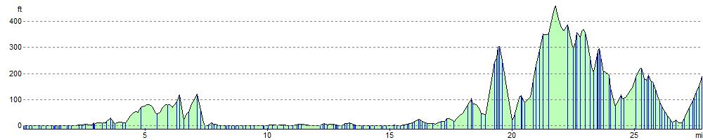
Elevation Profile