Bristol and Bath Railway Path Cycle with OS Map
![]()
![]() This lovely cycle or walk takes you along a disused railway line with its series of charming stations. Starting in the historic city of Bristol you will pass through Staple Hill, Mangotsfield and then Warmley where the station platform contains a cafe - perfect for a stop for refreshments.
This lovely cycle or walk takes you along a disused railway line with its series of charming stations. Starting in the historic city of Bristol you will pass through Staple Hill, Mangotsfield and then Warmley where the station platform contains a cafe - perfect for a stop for refreshments.
The route then takes you along the Avon Valley Railway and past Bitton railway station which also has a cafe.
The final delightful section takes you along the River Avon and into the historic city of Bath.
To extend the ride you can pick up the Kennet and Avon Canal in Bath. There's more easy cycling to be enjoyed along the flat towpath here.
See the Bristol Cycle Routes page for more cycling ideas in and around the city.
Bristol and Bath Railway Path Ordnance Survey Map  - view and print off detailed OS map
Bristol and Bath Railway Path Open Street Map  - view and print off detailed map
*New* - Walks and Cycle Routes Near Me Map - Waymarked Routes and Mountain Bike Trails>>
Bristol and Bath Railway Path OS Map  - Mobile GPS OS Map with Location tracking
Bristol and Bath Railway Path Open Street Map  - Mobile GPS Map with Location tracking
Pubs/Cafes
The Warmley Waiting Room is a good choice for a pit stop on the route. It's located in the original waiting room of the old Warmley Railway Station. There are also outdoor seating areas which include the gardens, summerhouse and on the platform itself. They serve substantial meals and some particularly delicious home made cakes. You can find the cafe at roughly the half way point on the route at a postcode of BS30 5JB for your sat navs.
Dog Walking
The path makes for a pleasant dog walk but please keep them on a lead or under close control because of the cyclists. The Warmley cafe mentioned above welcomes dog walkers.
Further Information and Other Local Ideas
To the west of Bath you will pass close to the village of Newton St Loe. The pretty village is worth a small detour from the route if you have time. It includes the attractive Newton College and Newton Park where there's an 18th-century landscaped garden, designed by the famous landscape gardener Capability Brown. There's also a historic 18th century country house and a fine 17th century pub to see too.
Just to the east of the path at Saltford you'll find the little village of Kelston where you can pick up the Kelston Roundhill Walk. This popular walk takes you up to an ancient barrow where there are wonderful views to the Wiltshire Downs, the Mendip Hills and the Black Mountains of Wales.
In Bristol there's the Bristol Triangular City Walk and the Bristol Circular River Walk to explore the city's highlights including the wonderful Blaise Castle Estate.
The Avon Cycleway uses the path. The long distance circular ride explores the area around Bristol, visiting the edge of the Cotswolds and the coast around Clevedon.
The Great Western Way starts at Bristol Temple Meads Railway station and uses the path. The trail runs from Bristol to London following the route of Isambard Kingdom Brunel's 19th century railway. It finishes at Southwark's Brunel Museum, where you can learn all about the life and works of the famous engineer.
Cycle Routes and Walking Routes Nearby
Photos

On the Avon Valley railway, with Oldland Common station just behind the bridge.

Bristol and Bath railway path crossing the river Avon.

River Avon, Kelston Park Railway Bridge. Rowers heading up against the current past the former railway bridge.

Kelston Park,from Seven Acre Wood near Newton St Loe, across the River Avon valley. The bridge over the river carries the Bristol and Bath Railway Path.

View of the surfaced path through a park in Newtown. Looking north east in the direction of Easton, this photo was taken near the start of the trail.

Looking down on the Bristol to Bath cycle path from above. The trail was the first cycle route created by Sustrans. Taken looking down from the bridge on Devon Road in Easton.
.jpg)
Oldland Common railway station, Gloucestershire. Opened in 1935 by the London Midland & Scottish Railway on the line from Bristol to Bath Green Park via Mangotsfield, this station closed to passengers in 1966. It was rebuilt (slightly further away from the camera position) in 1992 as part of what is now the heritage Avon Valley Railway. View north east towards Warmley and Mangotsfield.

Warmley Station. The station office is now a cafe.
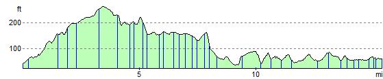
Elevation Profile