Bury to Clare Walk
![]()
![]() Follow the Bury to Clare Walk from Bury St Edmunds to Clare on this walk through Suffolk.
Follow the Bury to Clare Walk from Bury St Edmunds to Clare on this walk through Suffolk.
The path starts at Nowton Park in Bury St Edmunds and heads south passing Somerton, Hawkedon and Stansfield before finishing at Clare Castle Country Park where there are the ruins of the historic Clare Castle.
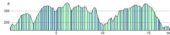
The route runs for a distance of about 19 miles with some small climbs on the way. As such it's possible to complete the walk in a day. Along the way there's a number of pretty little villages, lovely Suffolk countryside and views of the River Stour at the end of the walk in Clare.
Bury to Clare Walk Ordnance Survey Map  - view and print off detailed OS map
Bury to Clare Walk Open Street Map  - view and print off detailed map
*New* - Walks and Cycle Routes Near Me Map - Waymarked Routes and Mountain Bike Trails>>
Bury to Clare Walk OS Map  - Mobile GPS OS Map with Location tracking
Bury to Clare Walk Open Street Map  - Mobile GPS Map with Location tracking
Pubs/Cafes
In Bury head to the noteworthy Nutshell pub to refresh yourself. It's a quirky little place confirmed to be Britain's smallest pub, with a bar that measures just 15ft by 7ft. Despite its size there's a number of unusual items inside including a mummified cat, currency notes on the ceiling, historical photos, military items and an aeroplane propeller. As such the Victorian pub is a local tourist attraction and well worthy of some investigation. You can find them at 17 The Traverse, with a postcode of IP33 1BJ for your sat navs.
Further Information and Other Local Ideas
For more walking ideas in the area see the Suffolk Walks page.
Cycle Routes and Walking Routes Nearby
Photos

Bury to Clare walk at Thurston. The village of Somerton is on the hill in the distance

Photo of the footpath sign for the Bury to Clare walk near to Upper Street Suffolk.

Lime Avenue, Nowton Park at the start of the route.

Old Station from Clare Castle at the end of the route. The Old Station and platforms are now part of Clare Castle Country Park. The railway was closed during the Beeching era. The building itself is now the dwelling and offices of the park ranger. The pole to the left is Clare's millennium beacon.

Wheatfield near Mickley Green

Brockley Hall Farm in Brockley. A Grade I listed historic house.
Elevation Profile