Castleman Trailway
![]()
![]() Travel from Ringwood to Poole along the disused Southampton to Dorchester railway line on this easy cycle and walking route. Route highlights include 3 lovely country parks - Avon Heath Country Park, Moors Valley Country Park and Upton Country Park.
Travel from Ringwood to Poole along the disused Southampton to Dorchester railway line on this easy cycle and walking route. Route highlights include 3 lovely country parks - Avon Heath Country Park, Moors Valley Country Park and Upton Country Park.
The trail runs for a distance of about 15 miles on a fairly flat path so it's a good ride for families or anyone looking for an easy, sheltered walk.
For more information about this route please
click here.
Castleman Trailway Ordnance Survey Map  - view and print off detailed OS map
Castleman Trailway Open Street Map  - view and print off detailed map
Castleman Trailway OS Map  - Mobile GPS OS Map with Location tracking
Castleman Trailway Open Street Map  - Mobile GPS Map with Location tracking
Pubs/Cafes
The country parks on the route all have good cafes where you can stop off for some refreshments. At Avon Heath for example there's a splendid cafe with a good menu serving delicious coffee, cake, breakfasts & lunches. It's located at a postcode of BH24 2DH for your sat navs.
At Upton Country Park there's tea rooms with a lovely terrace where you can enjoy the beautiful surroundings of the Walled Garden. It's a great spot for a rest on a warm summer day.
Further Information and Other Local Ideas
Near Upton Country Park the trail passes Upton Heath. The nature reserve includes some good footpaths with heathland, lakes and fine views from the high points. Near here you will also pass Delph Woods in Corfe Mullen. The nature reserve includes some peaceful trails running along a pretty stream.
In Ferndown Forest the trail links up with the circular Ferndown, Stour and Forest Trail. There's some nice riverside paths and a visit to the pretty Longham Lakes on this pleasant route.
Head east and you can follow another section along the railway on the Old Railway New Forest Cycle Route. The trail runs from Brockenhurst to Burley on the Castleman's Corkscrew, another section of the old Southampton to Dorchester railway.
For more walking ideas in the area see the Dorset Walks page.
Cycle Routes and Walking Routes Nearby
Photos

Castleman Trailway. View of the trail near Ringwood. The way is part of the former Southampton and Dorchester Railway line which ran from Brockenhurst to Hamworthy Junction via Ringwood. It was known as "The Old Road".

LDP Waymark Castleman Trailway. The trail is named after Wimborne solicitor Charles Castleman who promoted the old train line in the 19th century. It was required back then because of the need to run a line through populated areas at a time when Bournemouth was just a small village.

Seat on Castleman Trailway. A metal seat with a leaf motif on the north side of the cycleway. The trail passes through woodlands, heathlands, meadows, and areas of scrubland, each contributing to its ecological diversity.
The woodlands along the trail are home to deciduous trees like oak, beech, and silver birch, while in the understorey, plants such as bramble, holly, and ferns are commonly found. In spring, bluebells, wood anemones, and primroses bring vibrant colour to the trail. Heathland sections, typical of Dorset, feature low-growing vegetation like heather, gorse, and bilberry, creating an important habitat for wildlife.

Castleman Trailway on a sunny day. Wildlife is abundant, with birds such as great tits, blackbirds, and robins frequently spotted in wooded areas, alongside less common species like treecreepers and goldcrests. Heathland sections are home to skylarks, stonechats, and Dartford warblers, while birds of prey, including buzzards and kestrels, can often be seen soaring above open areas. Mammals such as foxes, badgers, and deer are also present, with smaller mammals like voles and shrews found in grassy habitats.

Bridge carrying the Trailway over River Avon mill stream near Ringwood. The trailway follows the course of the dismantled Brockenhurst-Ringwood railway.
The trailway is also steeped in history. Named after Charles Castleman, the solicitor who spearheaded the railway project in the 19th century, it offers a unique glimpse into the area’s industrial past. Remnants of railway architecture, such as bridges and old track beds, can be seen along the route. The trail also connects with other nature reserves and Sites of Special Scientific Interest (SSSIs).

Castleman Trailway in Ferndown Forest. View of The Trailway crossing Uddens Water and heading south west

A view looking west towards West Moors village. Butterflies are a highlight of the trail in summer, with species like red admirals, peacock butterflies, and common blues often seen. In wetter areas and near ponds or streams, dragonflies and damselflies add to the variety of invertebrates. Amphibians, including common frogs and newts, may be found in suitable aquatic habitats.

Tree lined section near Lions Hill. A view looking north-east towards Ashley Heath
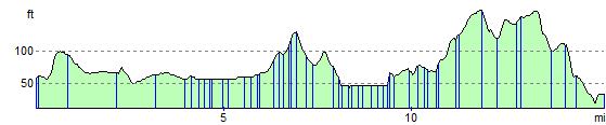
Elevation Profile