Chichester Canal Walk
![]()
![]() Enjoy a lovely waterside stroll along the Chichester Canal on this easy walk in Sussex. The walk begins in the centre of Chichester (near the train station and cathedral) following the canal towpath to Chichester Marina and Birdham where there are some great boats to see.
Enjoy a lovely waterside stroll along the Chichester Canal on this easy walk in Sussex. The walk begins in the centre of Chichester (near the train station and cathedral) following the canal towpath to Chichester Marina and Birdham where there are some great boats to see.
Although this is categorised as a walking route, cyclists can also enjoy the first section of the towpath from Chichester to Hunston.
The canal is great for wildlife so keep your eyes peeled for birds such as moorhens, coots, heron, kingfisher, whitethroat, common sandpiper, spotted flycatcher and woodpecker. You may also see foxes, deer and dragonflies as you may your way along the path.
You can turn it into a longer circular walk by heading north along the coastal path to Apuldram.
To extend your walking in the area you could head south and enjoy a lovely coastal walk at the RSPB Pagham Harbour reserve. You could also visit the nearby Chidham Peninsula and enjoy great views of Chichester Harbour.
In the city itself the Chichester Walls Walk is a great way of learning about the fascinating Roman history of the area.
Chichester Canal Ordnance Survey Map  - view and print off detailed OS map
Chichester Canal Open Street Map  - view and print off detailed map
*New* - Walks and Cycle Routes Near Me Map - Waymarked Routes and Mountain Bike Trails>>
Chichester Canal OS Map  - Mobile GPS OS Map with Location tracking
Chichester Canal Open Street Map  - Mobile GPS Map with Location tracking
Pubs/Cafes
At the end of the walk there's the excellent Boathouse Cafe at Chichester Marina where you can enjoy refreshments after your walk. There's a light and airy dining terrace so you can sit outside on warmer days. The cafe is also dog friendly if you have your canine friend with you.
Dog Walking
Please note that dogs should be kept on a lead at all times and should be discouraged from entering the water.
Further Information and Other Local Ideas
Just to the north west of the town there's the splendid Kingley Vale National Nature Reserve in the South Downs. The noteworthy reserve contains one of the finest yew forests in Europe, including a grove of ancient trees which are among the oldest living things in Britain.
On the western side of the town you could pick up the Centurion Way. This easy shared cycling and walking trail runs along the old Midhurst and Chichester railway track to West Dean.
On the eastern side of the canal there's some pleasant public footpaths across the Chichester Lakes. You can reach them by heading east from Poynze Bridge at Hunston.
For more walking ideas in the area see the Sussex Walks page.
Cycle Routes and Walking Routes Nearby
Photos
Looking towards the Cathedral in the distance on a fine late spring morning. The canal (originally part of the Portsmouth and Arundel Canal) was opened in 1822 and took three years to build.
The canal banks are lined with reeds, sedges, and grasses, providing ideal habitats for wetland plants. Seasonal wildflowers, such as buttercups, cow parsley, and red campion, bring colour to the towpath during spring and summer. The surrounding hedgerows and trees, including willows and alders, further enhance the biodiversity of the area.
Looking NNW from Poyntz Bridge, Hunston. Chichester Cathedral (SU8604) can be seen on the horizon. The canal, with a total length of 4 miles, was opened in 1822 and could accommodate boats up to 150 tons. Commercial use of the canal came to an end in 1906. It has now been restored and is an important habitat for wildlife. The former towpath on the west bank of the canal is a footpath from Chichester city to Chichester Marina.
Houseboats on the Chichester Canal. Each have their own individual ferry to get you to their front door. Looking west at the top of the square.
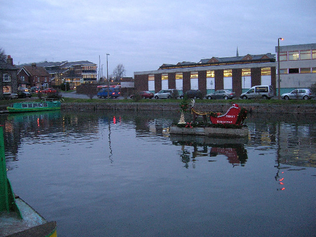
Chichester Canal Basin. Originally just a branch of a canal that was to link Portsmouth with London, Chichester is now the terminus of the restored canal that begins at Birdham. This view looks north taking in a festive visitor.
Cutfield Bridge. The canal supports an array of birdlife, making it a popular spot for birdwatching. Kingfishers are often seen darting along the water’s edge, while swans, mallards, and moorhens are common sights on the canal itself. During the winter months, the area attracts visiting waterfowl such as teal and wigeon. Overhead, buzzards and kestrels can sometimes be spotted, adding to the richness of the avian population.
Cyclist heading towards Crosbie Bridge. In and around the water, dragonflies and damselflies thrive in warmer months, while fish species such as roach and perch inhabit the canal. Frogs and toads are also present, particularly in the more secluded sections. Mammals like water voles, foxes, and the occasional deer may be seen near the water, especially during quieter times of day.


