Centurion Way
![]()
![]() This pleasant short route follows the Centurion Way along a disused railway path from Chichester to West Dean.
This pleasant short route follows the Centurion Way along a disused railway path from Chichester to West Dean.
The ride is flat and traffic free making it ideal for cycling families or walkers looking for a pleasant easy stroll through the Sussex countryside.
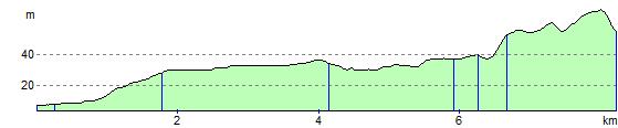
Starting just west of the town centre the route heads north to Mid Lavant before finishing at West Dean. It runs for a distance of just over 5 miles. You could turn it into a longer circular walk by picking up the Monarch's Way at West Dean and heading south east to climb The Trundle in Goodwood Country Park. There's some excellent views over the area from this elevated spot. From here you would then head south west along Chalkpit Lane to East Lavant before coming to the outskirts of Chichester.
The trail is coincident with the long distance New Lipchis Way which you can use to extend the walk.
Centurion Way Ordnance Survey Map  - view and print off detailed OS map
Centurion Way Open Street Map  - view and print off detailed map
Centurion Way OS Map  - Mobile GPS OS Map with Location tracking
Centurion Way Open Street Map  - Mobile GPS Map with Location tracking
Further Information and Other Local Ideas
The Kingley Vale National Nature Reserve lies just to the west of the path. There's some fine woodland trails here with lots of flora and fauna to see.
Cycle Routes and Walking Routes Nearby
Photos

Cycle path sculpture at Fishbourne. Immediately at the start of the Centurion Way cycle path at Fishbourne is a sculpture called the "Roman Archway". Made by Richard Farrington with the help of pupils from the Bishop Luffa School, the arch is a section taken from the hull of a wooden mine sweeper and is surmounted by designs taken from Romano-British mosaics. It reflects the Roman influence on the area, not least in the nearby Fishbourne Roman palace.

Near Binderton. The cycle path has been built on the very edge of the course of the old railway line, the rest of which has been taken back into the field on which it was built. The white chalk on the field shows its course.

Near Fishbourne. As the old railway curves away from its junction with the main line at Fishbourne there are a couple of leaning telephone poles to betray its origins.

Bridge at Brandy Hole Copse. Part of the old railway from Chichester to Midhurst has now been converted into the Centurion Way cycle path. This is the bridge at Brandy Hole Copse. The copse takes its name from the discovery, when the line was being built, of a barrel of brandy hidden in a cave.

Cycle path sculpture at Lavant. The Chichester Road Gang by David Kemp. This marks the spot where the Roman road from Silchester to Chichester was crossed by the old railway.

The New Lipchis Way meets the Romans. "The Chichester Road Gang" is a sculpture by David Kemp to mark the place where the line of the old Roman road crosses the modern footpath. The road bridge beyond carries the Hunters Race.

New Lipchis Way crosses the Lavant river

Bridleway Across the Lavant Valley, Sussex. The bridleway crosses the valley, heading towards Binderton House. In the centre of picture, the bridleway crosses over the trackbed of the former railway line between Midhurst and Chichester.
Elevation Profile