Circular Walk around Kettlewell
![]()
![]() This challenging circular walk climbs to Great Whernside, Blackfell Top and Blackfell Dike from the popular village of Kettlewell, in the Nidderdale area of the Yorkshire Dales.
This challenging circular walk climbs to Great Whernside, Blackfell Top and Blackfell Dike from the popular village of Kettlewell, in the Nidderdale area of the Yorkshire Dales.
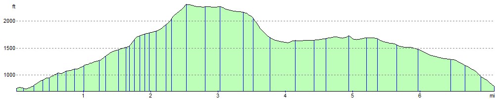
The route starts in the village and heads along the lovely Dowber Gill Beck where there's a series of pretty waterfalls. You continue to the Providence Pot cave where you turn left to Hag Dike. Turn right here and the path will take you directly up to the Great Whernside summit. It's a splendid viewpoint with views to the Lake District Fells, Pendle Hill, Wharfedale, Buckden Pike and the Pennines.
After soaking in the summit views the route descends to Blackfell Top, Black Dike and Tor Dike, where there are more nice views down the valley to enjoy.
The final section takes you along Starbotton Road before turning left down Top Mere Road. Follow the track for about 1.5 miles and it will return you to Kettlewell.
For a more direct path to the summit try the Great Whernside Walk.
The Dales Way long distance trail runs through the village. You could follow it north through Wharfedale to extend your exercise. It's a lovely riverside path which will take you to the village of Buckden where you can try the climb to Buckden Pike.
Heading in the other direction will take you to Grassington. You can see more details on the Grassington to Kettlewell Walk.
Circular Walk around Kettlewell Ordnance Survey Map  - view and print off detailed OS map
Circular Walk around Kettlewell Open Street Map  - view and print off detailed map
Circular Walk around Kettlewell OS Map  - Mobile GPS OS Map with Location tracking
Circular Walk around Kettlewell Open Street Map  - Mobile GPS Map with Location tracking
Pubs/Cafes
Back in the village The King's Head is a good choice for some well earned refreshments. The quality inn is ranked by The Sunday Times in the top 10 pubs in The Ultimate 100 British Hotels, as well as named in the Sunday Times Top 50 affordable hotels in the U.K. They do excellent homemade food and have a nice outdoor area for warmer weather. You can find them at The Green with postcode BD23 5RD for your sat navs. They also have a sister pub called The Blue Bell Inn which is dog friendly and can be found on Middle Lane at postcode BD23 5QX.
Further Information and Other Local Ideas
For an easy circular walk from the village try the Kettlewell to Starbotton and Arncliffe Walk. This route visits the two neighbouring villages which are both full of character. There's excellent views of the countryside of Wharfedale and the Littondale valley on this walk. Just to the north west of Arncliffe you can pick up the Littondale Walk. This starts from the nearby village of Litton and explores the northern end of the dale with more riverside trails and excellent views.
For more walking ideas in the area see the Nidderdale Walks page.
Cycle Routes and Walking Routes Nearby
Photos

Dowber Gill Beck - little waterfall

Dowber Gill - series of waterfalls

Valley and Dowber Gill Beck

Hag Dyke

Rocks at summit of Great Whernside

Stile by Black Dike Hole

Tor Dike View

Looking towards Top Mere above Starbotton
Elevation Profile