Conic Hill Walk From Balmaha
![]()
![]() This popular climb to Conic Hill gives wonderful views over Loch Lomond. The hill is situated above Balmaha and can be reached by following a good, stepped path along the West Highland Way to the summit. The walk starts from the Balmaha car park/visitor centre and heads through the woodland of the Balmaha plantation before climbing the wooden steps and following grassy paths to Conic Hill. The views back over Loch Lomond towards the Arrochar Alps and Ben Lomond are stunning. You can descend the same way or extend your walk by continuing along the West Highland Way to the Burn of Marr and Milton of Buchanan. This would turn the route into a longer circular walk.
This popular climb to Conic Hill gives wonderful views over Loch Lomond. The hill is situated above Balmaha and can be reached by following a good, stepped path along the West Highland Way to the summit. The walk starts from the Balmaha car park/visitor centre and heads through the woodland of the Balmaha plantation before climbing the wooden steps and following grassy paths to Conic Hill. The views back over Loch Lomond towards the Arrochar Alps and Ben Lomond are stunning. You can descend the same way or extend your walk by continuing along the West Highland Way to the Burn of Marr and Milton of Buchanan. This would turn the route into a longer circular walk.
Conic Hill Ordnance Survey Map  - view and print off detailed OS map
Conic Hill Open Street Map  - view and print off detailed map
*New* - Walks and Cycle Routes Near Me Map - Waymarked Routes and Mountain Bike Trails>>
Conic Hill OS Map  - Mobile GPS OS Map with Location tracking
Conic Hill Open Street Map  - Mobile GPS Map with Location tracking
Pubs/Cafes
The Oak Tree Inn sits in a lovely location next to Loch Lomond in Balmaha. The award winning inn serves good quality food and has a fine selection of ales. If the weather is fine you can sit outside under the eponymous oak tree. They also provide rooms if you would like to stay in the area. You can find them at postcode G63 0JQ for your sat navs.
Further Information and Other Local Ideas
One nice idea is to catch the ferry to the picturesque Inchcailloch Island where you can enjoy nature trails and a little beach. You could also explore miles of woodland trails around Balmaha Forest.
The epic West Highland Way also runs through Balmaha. You could pick up the long distance trail and follow it north along the loch to Rowardennan on the Balmaha to Milarrochy Bay and Rowardennan Walk. It's a popular section of the waymarked trail with a visit to the beautiful Milarrochy Bay a real highlight.
For more walking ideas in the area see the Loch Lomond and the Trossachs Walks page.
Cycle Routes and Walking Routes Nearby
Photos

Loch Lomond from The West Highland Way. Looking south west from just below the summit ridge of Conic Hill. This picture is looking right along the line of the Highland Geological Fault to the islands of from nearest Inchcailloch, Torrinch, Creinch and Inchmurrin, Ben Bowie is the hill seen on the other side of the Loch.

Conic Hill. The summit is grassy and heather moor. In the right background is Ben Lomond.
As you ascend, you'll pass through areas of mixed woodland, including birch, rowan, and oak trees, which are particularly vibrant in spring and autumn. The open grassy slopes are interspersed with patches of heather, gorse, and bracken. In summer, wildflowers such as foxgloves and buttercups can be seen along the paths, adding colour to the landscape and attracting pollinators like bees and butterflies.

Conic Hill Summit. On a clear day it is possible to see Goat Fell on the Isle of Arran, about 50 miles south west. The rounded outline of Ailsa Craig in the Clyde Estuary can also be seen.
The fauna of the area is equally engaging. Birds are a highlight, with species such as skylarks, buzzards, and kestrels commonly seen or heard overhead. During quieter times, you might spot deer grazing in the more remote areas or red squirrels darting through the trees. The hill also provides a habitat for smaller mammals, such as voles and rabbits, while Loch Lomond itself supports waterfowl like mallards, grebes, and herons, visible from the hill’s vantage points.

Car park and visitor centre, Balmaha. With a fine view to the Conic Hill in the background.

The path into the Bealach Ard. On the far side of the bealach (pass) can be seen Tom nan Oisgean. Conic Hill is part of the Highland Boundary Fault, a geological feature marking the boundary between the Lowlands and Highlands of Scotland. This creates a striking landscape and provides panoramic views over Loch Lomond and its islands, particularly from the summit.

West Highland Way in Balmaha Plantation. A pleasant, surfaced stone path through the trees on the ascent to the hill.

View from Conic Hill West

Path leading up to the hill in summer.
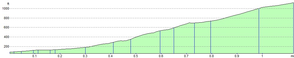
Elevation Profile