Consett and Sunderland Railway Path
![]()
![]() A walk or cycle along a disused railway path from Consett to Sunderland. The path starts at Consett and heads east towards the coast passing Stanley and Chester-le-Street before joining the River Wear and following it to Sunderland harbour. You'll also pass Beamish Woods where there's some nice woodland trails and the views of the River Team.
A walk or cycle along a disused railway path from Consett to Sunderland. The path starts at Consett and heads east towards the coast passing Stanley and Chester-le-Street before joining the River Wear and following it to Sunderland harbour. You'll also pass Beamish Woods where there's some nice woodland trails and the views of the River Team.
It's a fairly flat surfaced path with a number of sculptures, interesting earthworks and fine views of the Durham countryside to enjoy.
Consett and Sunderland Railway Path Ordnance Survey Map  - view and print off detailed OS map
Consett and Sunderland Railway Path Open Street Map  - view and print off detailed map
Consett and Sunderland Railway Path OS Map  - Mobile GPS OS Map with Location tracking
Consett and Sunderland Railway Path Open Street Map  - Mobile GPS Map with Location tracking
Further Information and Other Local Ideas
At Consett the route links with three other rail trails where you can extend your walking or cycling. These include the Waskerley Way the Derwent Valley Walk and the Lanchester Valley Walk.
Just west of Consett there's one of the highlights of the area at Pow Hill Country Park and Derwent Reservoir near Edmundbyers.
Just west of Consett the pretty Allensford Country Park is well worth a visit. There's nice riverside trails, a decent cafe and a lovely waterfall on the Wharnley Burn.
For more walking ideas in the area see the County Durham Walks and the Tyne and Wear Walks pages.
Cycle Routes and Walking Routes Nearby
Photos

The Consett and Sunderland railway path is a component of the C2C cycle route, and carries large numbers of recreational cyclists throughout the year. The section pictured here runs between Lydgett Junction and the Consett By-pass

Sculptures on the path

NCN Millennium Milepost at Stanley, County Durham

"The ravines" at New Kyo. "The ravines" are a series of artistic earthworks which form an interesting obstacle on the Consett and Sunderland railway path (part of the C2C Cycle Route)

The Lambton Worm. This sinuous earthwork, designed by Andy Goldsworthy, commemorates the local mythical beast "the Lambton Worm".

Shorthorn cattle sculpture at Beamish, County Durham. Built by Sally Matthews, the Beamish Shorthorns, constructed from scrap metal contentedly graze by the side of the trail. A group of cyclists can be seen admiring the piece.

Jolly Drover's Roundabout, Leadgate. This roundabout on the A692 is traversed at this point by the Consett and Sunderland railway path on the C2C cycle route. In the middle ground, to the left, although not clear on this photograph, is "the Maze" a complex earthworks by Andy Goldsworthy, through which the cycle path wends its way.

The Crucible on the C2C. This relic of the once mighty steelworks at Consett marks the spot where four railway paths meet - the Waskerley Way from Stanhope Moor, the Consett and Sunderland path, the Derwent Valley Path down to Gateshead and the Lanchester Path down to Durham.
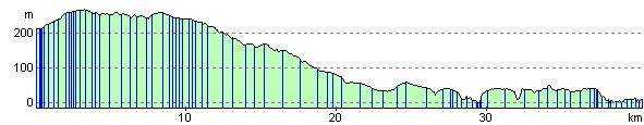
Elevation Profile