Coombe Hill Circular Walk from Wendover
![]()
![]() Climb to the 260 m (850 ft) summit of this lovely hill in the Chilterns. Coombe Hill is the highest viewpoint in the Chiltern Hills and commands wonderful views over Aylesbury Vale and the Cotswolds.
Climb to the 260 m (850 ft) summit of this lovely hill in the Chilterns. Coombe Hill is the highest viewpoint in the Chiltern Hills and commands wonderful views over Aylesbury Vale and the Cotswolds.
This circular walk starts in Wendover, near the train station, and follows the Ridgeway long distance trail to the summit. It's a nice, grassy footpath taking you over the delightful Bacombe Hill. There's a series of nice woodland paths and the area is also a nature reserve so look out for pretty wildflowers and over 20 species of butterfly. The summit is a special place with the iconic Coombe Hill Monument. It was erected in 1904 in memory of 148 men from Buckinghamshire who died during the Second Boer War. As well as the great views over the Chilterns AONB you can also see Chequers, the country home of the Prime Minister from the summit.
From the summit you descend on more nice woodland paths to Dunsmore and then back into Wendover.
You could also visit the hill from the south by climbing from nearby Princes Risborough along the Ridgeway. Our walk starts from the town's train station and visits the attractive nature reserves at Pulpit Hill and Whiteleaf Hill on the way.
To extend your walking in the area you can pick up the Wendover Canal Arm of the Grand Union Canal. It starts in the town and heads to the nearby Weston Turville Reservoir, Tring Reservoirs and Bulbourne.
Also of interest is Wendover Woods where there's miles of good walking and cycling trails to be found. In the woods you can also enjoy a climb to the summit of Haddington Hill, the highest point in the Chilterns.
Postcode
HP17 0UR - Please note: Postcode may be approximate for some rural locationsPlease click here for more information
Coombe Hill Ordnance Survey Map  - view and print off detailed OS map
Coombe Hill Open Street Map  - view and print off detailed map
*New* - Walks and Cycle Routes Near Me Map - Waymarked Routes and Mountain Bike Trails>>
Coombe Hill OS Map  - Mobile GPS OS Map with Location tracking
Coombe Hill Open Street Map  - Mobile GPS Map with Location tracking
Pubs/Cafes
The Russell Arms is conveniently located a stone's throw from the hill in Butler's Cross. The historic pub was originally an 18th century coach house. Its name dates back to the family that once owned Chequers (approximately 1 mile away) and the pub itself was where many of the staff that worked at Chequers lived. The inn has an extensive menu and a nice outdoor seating area for warmer days. You can find it about 100 metres north of the hill at 2 Chalkshire Roadd, Butlers Cross with a postcode of HP17 0TS for your sat navs.
Dog Walking
The hill and the surrounding woods are ideal for a dog walk. The Russell Arms pub mentioned above also welcomes dogs, providing water and dog biscuits for your thirsty friend.
Further Information and Other Local Ideas
This route is accessible by public transport from Wendover train station. The station is on the London Marylebone — Aylesbury line and is served by Chiltern Railways trains. It is located between Great Missenden and Stoke Mandeville stations.
It's quite quick and easy to reach the town from the capital. At peak times there are up to four trains per hour towards London in the morning, and returning from London (towards Aylesbury) in the evening. Some of these are express services, which skip the stops shared with the Metropolitan line nearer to London. The journey time is only about 50 minutes and 40 minutes for express trains so it makes for a nice day trip for London. Journeys to nearby Aylesbury take about 10 minutes.
Cycle Routes and Walking Routes Nearby
Photos

Ridgeway climbing Coombe Hill. Pleasant climb through woodland - pity about the weather. The chalk grassland that covers much of the hill is rich in wildflowers during the spring and summer months, including orchids, cowslips, and harebells, which provide essential habitats for pollinators such as butterflies and bees. Areas of woodland, mainly beech and ash, fringe the paths, offering shade and shelter for a variety of birds and mammals. In autumn, the changing colours of the trees create a stunning backdrop to the walk.

Boer War Memorial on Coombe Hill. The memorial was unveiled in 1904, in memory of the men from Buckinghamshire who had died in the Boer War. Standing some 843 feet (257 metres) above sea level (about 10 feet/3 metres lower than the summit of the hill) on the edge of the Chiltern escarpment, it can be seen from a great distance

Butlers Cross, The Russell Arms pub. A nice place to visit after your walk

The path up Bacombe Hill Nature Reserve. The fauna on Coombe Hill is equally varied. Skylarks can often be heard singing over the open grassland, while red kites and buzzards are commonly seen soaring overhead. The hill is also home to small mammals such as rabbits and occasional sightings of deer. Alongside this, the hedgerows and shrubs support songbirds like blackbirds and robins, especially in quieter parts of the trail.

Three layers of trees. This view was taken from the Ellesborough Road. There is a row of quite short trees along the field boundary, behind that is a copse or small wood, then rising behind this is the densely wooded continuous scarp of the Chilterns between Bacombe and Coombe Hills.
A nice grassy footpath on Bacombe Hill
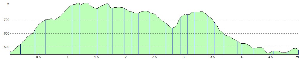
Elevation Profile