Crewe and Nantwich Circular Walk
![]()
![]() This circular walk takes you through the countryside and villages surrounding Crewe and Nantwich.
This circular walk takes you through the countryside and villages surrounding Crewe and Nantwich.
You start off at Coppenshall just north of Crewe and first head to Weston. This section takes you past Sandbach Flashes wetlands (good for bird watching) and also the tudor house at Haslington.
From Weston you head towards Acton passing Hough Common, Wybunbury and Austerson. Highlights on this section include Shrewbridge Lake and Dorfold Hall Jacobean mansion. You will also cross the River Weaver and the Shropshire Union Canal.
The final section takes you back to Coppenshall from Acton, passing Henhull and Church Minsall on the way. This section also includes a pleasant section along the towpath of the Shropshire Union Canal.
Crewe and Nantwich Circular Walk Ordnance Survey Map  - view and print off detailed OS map
Crewe and Nantwich Circular Walk Open Street Map  - view and print off detailed map
Crewe and Nantwich Circular Walk OS Map  - Mobile GPS OS Map with Location tracking
Crewe and Nantwich Circular Walk Open Street Map  - Mobile GPS Map with Location tracking
Further Information and Other Local Ideas
For another circular walk in the area see the Nantwich Riverside Loop. This waymarked trail explores the western side of the town, visiting the River Weaver and the Shropshire Union Canal. Other highlights on the walk include the pretty Nantwich Lake, the 1803 Nantwich Bridge and the splendid 19th century Nantwich Aqueduct.
Cycle Routes and Walking Routes Nearby
Photos

Stile on the Crewe & Nantwich Circular Walk At Cross Lane. The trail leaves the towpath of the Middlewich Branch of the Shropshire Union Canal at Minshullhill Bridge (out of view to left) to head NW towards Brookhouse Lane. The flat pasture beside the canal shown here is typical of much of this grid square.

Outside Acton. The land use around Acton is agricultural, predominantly cattle pasture with some arable, with many scattered mature trees. View from the Crewe and Nantwich Circular Walk just outside Acton; St Mary's Church is visible (right)

Dorfold, near Acton

Fields seen from Footpath

Shropshire Union Canal approaching Nantwich, Cheshire. David's Bridge (No 90) carries a farm track and bridleway. The recreational "Crewe and Nantwich Circular Walk" is also routed across the bridge.

Dairy Farm, Minshull Vernon. Minshull Vernon. View from Crewe & Nantwich Circular Walk towards Dairy Farm. This farm is unimaginatively, but very appropriately, named! In the middle of flat dairy farming countryside north of Crewe.
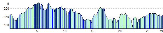
Elevation Profile