Downs Link - Guildford to Shoreham
![]()
![]() This is a terrific walking or cycling path running from St Martha's Hill in Guildford to Shoreham by Sea.
This is a terrific walking or cycling path running from St Martha's Hill in Guildford to Shoreham by Sea.
The trail is suitable for walkers and cyclists and links the North and South Downs National Trails. It runs for a distance of just under 40 miles on a fairly flat off road path with great views of the Low Weald countryside.
You start on St Martha's Hill with terrific views of the Surrey countryside before heading south to Cranleigh along the Wey and Arun Canal. The path continues to Rudgwick and then onto the delightful Southwater Country Park. The park is one of the highlights on the route with a series of pretty lakes and lots of wildlife to look out for.
The next stage takes you to Henfield and then onto Bramber with its ruined 11th century Bramber Castle. The final stage runs along the River Adur taking you to Shoreham-by-Sea.
You can extend the ride by heading east along National Cycle Network Routes to Brighton via Portslad and Hove. See the Guildford to Brighton Cycle Route for more details.
Please click here for more information
Downs Link Ordnance Survey Map  - view and print off detailed OS map
Downs Link Open Street Map  - view and print off detailed map
Downs Link OS Map  - Mobile GPS OS Map with Location tracking
Downs Link Open Street Map  - Mobile GPS Map with Location tracking
Pubs/Cafes
The attractive West Sussex village of Henfield is a nice place for a pit stop on the route. Here you will find the historic Plough of Henfield which dates all the way back to the 17th century. They do very good food and also have a lovely garden area for warmer days. You can find them on the High Street at postcode BN5 9HP for your sat navs.
In Cranleigh there's the 17th century Three Horseshoes to consider. The old fashioned village inn has a delightful interior with wooden floors, nooks, crannies and beams and even an inglenook fireplace with a roaring fire in winter. Outside there's a lovely garden area with lots of plants and herbs and private "wine huts" available for booking.
They serve good quality food and have a fine selection of real ales too.
You can find them on the High Street with postcode GU6 8AE for your sat navs.
In Rudgwick the Fox Inn is another worthy option. The historic inn dates back to the 16th century and includes low beams and wooden floors. They serve a fine Sunday Roast and also have an extensive garden area and car parking. You can find them at Bucks Green with postcode RH12 3JP for your sat navs.
Dog Walking
The open trail is a nice one to do with your dog though be aware there will be some cyclists to share the path with. The Plough mentioned above is also dog friendly with biscuit treats and bowls of water available.
Further Information and Other Local Ideas
The trail links with The South Downs Way and North Downs Way at opposite ends so you can continue your exercise on these waymarked trails.
Cycle Routes and Walking Routes Nearby
Photos

Downs Link. Long distance bridleway and cycle path that connects Shoreham to Guildford. Much of the route follows the course of two railways, this one being the former Shoreham-Horsham line that opened in 1861 and closed in 1966.

The path was opened in 1984 and here travels under the Shoreham By-Pass opened in 1968.

A walker and their dogs make their way along the path at Birtley Green.

Downs Link Junction and fingerposts. Track junction where the Shamley Green Link heads eastwards, under the Down Link footbridge.

Bramley Wooded section, just south of the former Bramley Station

Seat on Downs Link. There are a lot of seats on the trail but many of them have had their intended views obscured by untrimmed hedgerows. Happily, this one has a broad view over the fields of Violets Farm and all the way up to Hermongers Country House.

This waterside section runs along the River Adur just north of Shoreham

Footbridge. Sturdy wooden bridge by Birtley Green carries the long distance path over the Shamley Green Link path.
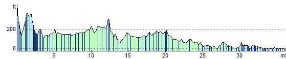
Elevation Profile