River Adur and Bramber Castle

 Follow a waterside path along the River Adur to Bramber Castle on this walk in West Sussex.
The route runs for about 4.5 miles from Shoreham to Upper Beeding before finishing at the historic castle ruins. It's a nice flat riverside path with a small climb up to the castle at the end of the route. The route can be started just to the north west of Shoreham train station where you can pick up the river footpath. Follow it north and it will take you to Bramber with some lovely river and country views on the way.
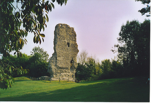
The castle dates from the 11th century and also includes the more complete church which was built as part of the castle residences and buildings. It remains in use today.
River Adur and Bramber Castle Ordnance Survey Map  - view and print off detailed OS map
River Adur and Bramber Castle Open Street Map  - view and print off detailed map
River Adur and Bramber Castle OS Map  - Mobile GPS OS Map with Location tracking
River Adur and Bramber Castle Open Street Map  - Mobile GPS Map with Location tracking
Further Information and Other Local Ideas
To continue your walking from Bramber you can pick up the South Downs Way or the Monarch's Way and follow the waymarked trails west onto the South Downs. Here you can visit the historic hill fort at Cissbury Ring and enjoy wonderful views over the area.
The castle is located very close to the attractive market town of Steyning. The town is worth exploring with a fine high street and a number of Tudor style half timbered houses and smart Georgian town houses to see. You can also try the
Steyning Walk which takes you north along the River Adur to Stretham.
Just to the west is the Lancing Ring Nature Reserve. The reserve is a great place for wildlife walks with splendid views over the Adur Valley from the high points.
The circular Worthing Walk starts from the nearby coastal town and visits the fort and the castle.
For more walking ideas in the area see the Sussex Walks and South Downs Walks pages.
Cycle Routes and Walking Routes Nearby
Photos
Motte, Bramber Castle. Just the mound remains now overgrown by trees. The castle was built in 1073 and was derelict by the 16th century.
Bramber Castle ruin. This is just the what is left of the Gatehouse tower,some floor joist holes, can still be seen. It is a pleasant place to sit and have a picnic in the shadow of the remains of the old Norman castle.


