Exe Valley Way
![]()
![]() The walk starts in Starcross on the banks of the River Exe Estuary and heads past the 14th century Powderham Castle and then along the Exeter Canal to Exeter.
The walk starts in Starcross on the banks of the River Exe Estuary and heads past the 14th century Powderham Castle and then along the Exeter Canal to Exeter.
The next section continues along the River Exe to Tiverton via Thorverton and Bickleigh.
The final section takes you from Tiverton into the Exmoor National Park where you will pass through Dulverton and Hawkridge before the finish at Exford in Somerset. This section passes close to the old clapper bridge at Tarr Steps near Dulverton and Withypool. It's well worth a short detour if you have time. Around here you'll also cross the picturesque five arched Landacre Bridge over the River Barle.
The route finishes near Dawlish Warren where there is a lovely nature reserve with lots of waders to look out for. You can also pick up the Dawlish Sea Wall and enjoy a stroll along the train line, beach and red sandstone cliffs to nearby Dawlish.
Exe Valley Way Ordnance Survey Map  - view and print off detailed OS map
Exe Valley Way Open Street Map  - view and print off detailed map
*New* - Walks and Cycle Routes Near Me Map - Waymarked Routes and Mountain Bike Trails>>
Exe Valley Way OS Map  - Mobile GPS OS Map with Location tracking
Exe Valley Way Open Street Map  - Mobile GPS Map with Location tracking
Pubs/Cafes
Tarr Steps Farm is a popular choice for walkers looking to refresh themselves on this walk. The 16th-century riverside inn is located near Liscombe at postcode TA22 9PY. There's outdoor seating with lovely views and a great menu.
Also on the route there's the historic Bickleigh Mill where there's an 18th century mill and number of shops an eateries. In the village there's also the splendid Fisherman's Cot. This historic country pub is in a lovely location next to the River Exe. It's a special place with a fabulous thatched roof, chimneys, and tall windows. There's a smashing beer garden right next to the water where you can relax on warmer days. The idyllic inn does very good food and is also dog friendly if you have your four legged friend with you. You can find it in the village at postcode EX16 8RW for you sat navs.
Just north of Exeter you will pass the attractive village of Brampford Speke where you will find The Agricultural Inn. The 18th century inn has a fine interior with exposed beams and cosy open fires. Outside there's a lovely secret garden area with pods. You can find them in a nice location opposite the village Church at postcode EX5 5DP for your sat navs.
Further Information and Other Local Ideas
Just a few miles north east of Exeter there's the wonderful Killerton Park Estate to explore. The National Trust owned park covers thousands of acres with miles of great cycling and walking trails surrounding the 18th century mansion. The historic village of Broadclyst and the peaceful woodland trails around Ashclyst Forest can also be found in this area.
For more walking ideas in the area see the Devon Walks, Somerset Walks, and Exmoor Walks pages.
Cycle Routes and Walking Routes Nearby
Photos

Exeter Canal and Exe Valley Way. The canalside path is part of the trail and also the South West Coast Path

Cattle at Powderham. One of series of old drainage channels across a meadow. Part of the hamlet of Powderham is in the background, with Powderham Castle on the right. Seen from Powderham Footpath 3, which now carries the Estuary Trail as well as the Exe Valley Way.

Steps leading down from the flood protection wall. The Exe Estuary Trail follows the wall; a popular destination for those using it is the Turf Hotel, visible in the distance.

Estuary and footpath near Turf lock

East Barton from the trail. Looking across the Exe; the farm buildings at East Barton are beside the A396.

Nether Exe countryside

Alphin Brook and Exeter Canal. The building and extension of the canal has meant the diversion of the brook on the left, which flows alongside the towpath (towards the camera). Marsh Barton Industrial Estate on the left.

Seat and train, Starcross. A Paddington-bound train passes the green at Starcross, with the car park to the right.
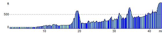
Elevation Profile