Gradbach Walks
![]()
![]() This little hamlet in the Peak District is an ideal place to start a walk with several Peak District highlights nearby. The hamlet includes a free car park and an 18th century mill. The mill is now a decent Youth Hostel so you can stay over if you need to as well.
This little hamlet in the Peak District is an ideal place to start a walk with several Peak District highlights nearby. The hamlet includes a free car park and an 18th century mill. The mill is now a decent Youth Hostel so you can stay over if you need to as well.
This route visits Lud's Church, The Roaches, Hen Cloud, Three Shires Head, the Dane Valley and Gradbach Wood. All these sites are located close to the hamlet and are reachable on foot.
The walk starts from the public car park in Gradbach. Near here you'll find the picturesque Gradbach Mill on the River Dane. From here you can pick up a section of the Dane Valley Way and follow the waymarked trail west along the River Dane. After about a mile you leave the river to follow woodland trails to Lud's Church. Here you'll find an impressive gorge with interesting rock formations. The Millstone Grit geological formation is covered in moss and has an unusual atmospheric feel to it.
The route then heads south through Gradbach wood to the Roaches. Here you can enjoy a series of gritstone boulders and wonderful views from the elevated position of this popular ridge top. At the southern end of the Roaches you can enjoy a climb to Hen Cloud. There's more interesting rock formations and fine views from this small hill.
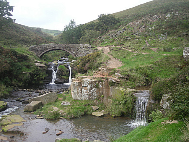
The route then heads north east past Five Clouds to return to Roach End. You then head east and north to head past Gradbach Hill before returning to the car park. You then follow the Dane Valley Way and other paths to visit Three Shires Head. The picturesque site is notable as the point where the counties of Cheshire, Derbyshire and Staffordshire meet. There's lots of pretty waterfalls and a wonderful grade II listed packhorse bridge over the River Dane. From here you can pick up country lanes and head south to return to the car park at Gradbach.
Postcode
SK17 0SU - Please note: Postcode may be approximate for some rural locationsGradbach Ordnance Survey Map  - view and print off detailed OS map
Gradbach Open Street Map  - view and print off detailed map
Gradbach OS Map  - Mobile GPS OS Map with Location tracking
Gradbach Open Street Map  - Mobile GPS Map with Location tracking
Pubs/Cafes
In nearby Wincle there's the Ship Inn to visit. The historic pub dates all the way back to the 16th century and has a cosy interior with fires to warm yourself by during the colder months. In the summer you can sit outside in the little beer garden. There's a good menu and decent selection of ales at this fine village pub. You can find the Ship at Barlow Hill, Wincle with a postcode of SK11 0QE for your sat navs. Near here you can also visit the excellent Wincle brewery. The site includes a small shop and tasting room where you can sample some of the 'eccentric' ales brewed here.
Further Information and Other Local Ideas
To continue your walking in the area you could follow the Dane Valley Way north to explore the expansive Axe Edge Moor near Buxton.
Head west and you can follow the riverside path to the nearby village of Danebridge.
To the north there's Wildboarclough where there's a fine 17th century pub, a Georgian hall and a beautiful valley to explore. You can also start the climb to the excellent viewpoint at Shutlingsloe from here.
For more walking ideas in the area see the Staffordshire Walks, Peak District Walks and White Peak Walks pages.
Cycle Routes and Walking Routes Nearby
Photos
The Old Mill at Gradbach and The River Dane. The former water-powered flax mill (centre) on the banks of the River Dane dates from 1785 and was used to manufacture sewing silk. On the right is the former manager's house; the workers' cottages were demolished when the mill became uneconomic. The buildings were converted into a Youth Hostel in 1980. The footbridge adjacent to the mill building is visible (left) and the footpath in the foreground leads to another footbridge over the Black Brook tributary.
Footbridge over Black Brook. This sturdy footbridge crosses the River Dane tributary, Black Brook, in deciduous woodland near the junction between several footpaths along Dane Valley and through Gradbach Wood. The bridge has stone-faced supports, metal rails and a wooden gate.


