Grindslow Knoll
![]()
![]() This challenging circular walk visits Grindslow Knoll and Grindsbrook Clough in Edale in the Peak District. It's a beautiful area with interesting rock formations and wonderful sweeping views over the Peak District.
This challenging circular walk visits Grindslow Knoll and Grindsbrook Clough in Edale in the Peak District. It's a beautiful area with interesting rock formations and wonderful sweeping views over the Peak District.
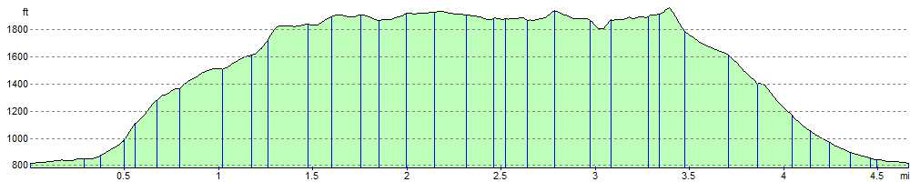
The walk starts from the pretty village of Edale which can be reached by train from Manchester or Sheffield. You then ascend to the Nab where there are splendid views of the Hope Valley. You continue to Ringing Roger where you will find a fascinating formation of weathered rocks and another fabulous viewpoint. The route continues along the spectacular Kinder Plateau, passing Nether Tor and Upper Tor before reaching Grindsbrook Clough. There is a popular alternative footpath here which runs along the Grindsbrook Clough back to Edale. It's a lovely waterside section along the Grinds Brook with pretty waterfalls along the way. This route, however continues to the summit of Grindslow Knoll, where there are great views of the Kinder Plateau, the Hope Valley and the Great Ridge. From here, the walk descends back to Edale where you can enjoy refreshments at the Old Nags Head pub. The pub is famous for being the start of the Pennine Way long distance walk.
Grindslow Knoll Ordnance Survey Map  - view and print off detailed OS map
Grindslow Knoll Open Street Map  - view and print off detailed map
Grindslow Knoll OS Map  - Mobile GPS OS Map with Location tracking
Grindslow Knoll Open Street Map  - Mobile GPS Map with Location tracking
Further Information and Other Local Ideas
For more walking ideas in the area see the Derbyshire Walks and the Peak District Walks pages.
Cycle Routes and Walking Routes Nearby
Photos

Across Grindsbrook Clough towards Grindslow Knoll

Along Crowden Brook from near Grindslow Knoll

Edale from Grindslow Knoll. The view looking south-east from the summit of Grindslow Knoll into Edale, in the Peak District. In the distance are Lose Hill and Win Hill.

Looking south-east to the summit of Grindslow Knoll, on the southern edge of the Kinder plateau, with Grindsbook Clough to the left and Lose Hill in the distance.

Head of Grindsbrook Clough, Edale. A winter view from the southern edge of the Kinder Scout plateau looking down the head of one of the two steep gullies at the head of Grindsbrook Clough.

Towards the Knoll from Upper Booth
Elevation Profile