Hamstead Trail
![]()
![]() Cross the western end of the Isle of Wight from north to south, and enjoy spectacular coastal views on this splendid trail.
Cross the western end of the Isle of Wight from north to south, and enjoy spectacular coastal views on this splendid trail.
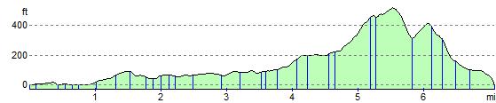
The trail starts at Hamstead Point on the northern coast, and climbs towards Shalcombe Down, passing Cranmore and Wellow on the way. This first section passes through woodland, near Cranmore, where red squirrels are often spotted.
As the path climbs through Wellow and Shalcombe Down you will enjoy fabulous views of the Isle of Wight coastline, including The Needles and St Catherines Point. The walk finishes descending to Brook Bay on the southern coast of the island.
The Tennyson Trail and the Freshwater Trail from Yarmouth to Freshwater Bay are good options for extending your walking in this part of the island.
Please click here for more information
Hamstead Trail Ordnance Survey Map  - view and print off detailed OS map
Hamstead Trail Open Street Map  - view and print off detailed map
Hamstead Trail OS Map  - Mobile GPS OS Map with Location tracking
Hamstead Trail Open Street Map  - Mobile GPS Map with Location tracking
Further Information and Other Local Ideas
Near the start of the trail you could pay a visit to the lovely village of Newtown. Here you'll find a wildlife rich National Nature Reserve and a medieval village with an interesting local history.
Cycle Routes and Walking Routes Nearby
Photos

On the Hamstead Trail. The trail is one of the islands named trails, running from south to north across the western part of the island. Here it passes through pleasant woodland near Mount Farm.

Near Hamstead Point. A small section of land goes into this square. From just off shore we can clearly see a concrete ramp running down into the water. This is probably a launching point for trails of amphibious craft during WW2.

Coastal path junction. Much of the south-west part of the square consists of mixed woodland, with two significant tracks going through it. They meet here, the north-south one on the right of the picture and the Coastal Path and Hamstead Trail coming in from the left. They are all footpaths only as the roads themselves are private.

Disused pits below Wellow Down. From above this combe looks natural. But there are old chalk pits here.
The path to the right is the Hamstead Trail across the island from south to north as it descends Wellow Down.

Coastal path approaching Hamstead. The coastal path has had to divert inland a little here, and crosses a number of small fields on its way to the hamlet of Hamstead. Unusually, it is not that clearly marked, but heads over this stile towards the gate beyond, where it reaches the lane leading to Hamstead. The south-east corner of the square has a number of small fields like this.

Vines at Rossiters Vineyard. Viewed from the trail the first of the vines are seen. In October, these have given up their crop for the year, but still retain their distinctive leaves.

Barn near The Quarries. This isolated barn is prominently marked on both main scales of map. As one heads north along the Hamstead Trail woodland quickly gives way to arable then sheep grazing here.

Footpath to Churchill's Farm from the Trail. A footpath, just discernible across the field, heads east towards Churchill's Farm. The stream in the dip flows north towards Wellow and the boundary of this arable part of the square is just beyond.
Elevation Profile