Hangers Way Walk Map
![]()
![]() Travel through Hampshire from Alton to the Queen Elizabeth Country Park along this 21 mile walking path.
Travel through Hampshire from Alton to the Queen Elizabeth Country Park along this 21 mile walking path.
The route passes through the delightful village of Selborne where you can take a detour to visit the lovely Selborne Common. There's nice footpaths here and varierty of flora and fauna to see. The village is also notable for its links with the world-famous naturalist, Revd. Gilbert White, who was a pioneer of birdwatching. White is recognised as being the first ecologist or environmentalist.
From Selborne you continue to Noar Hill and the attractive market town of Petersfield before finishing at Queen Elizabeth Country Park.
Scenery includes the beautiful woodland and grassland of the Hampshire countryside, while passing a series of steep-sided hills called the Hampshire Hangers, from which the path takes its name.
See the Hampshire CC website for more information on walks in the area.
Hangers Way Ordnance Survey Map  - view and print off detailed OS map
Hangers Way Open Street Map  - view and print off detailed map
*New* - Walks and Cycle Routes Near Me Map - Waymarked Routes and Mountain Bike Trails>>
Hangers Way OS Map  - Mobile GPS OS Map with Location tracking
Hangers Way Open Street Map  - Mobile GPS Map with Location tracking
Pubs/Cafes
In Petersfield you can stop for refreshments at The Old Drum on Chapel St at postcode GU32 3DP. The contemporary country pub is located in the centre of Petersfield and has a lovely beer garden. Built in the 18th Century, it is the oldest in the area and has been beautifully restored to keep its character and charm.
At the other end of the trail there's The George in Alton to consider. The pub has a lovely beer garden to sit out in if the weather is fine. You can find it on Butts Road at a postcode of GU34 1LH for your sat navs.
In Buriton you can stop at The Five Bells, a traditional country pub with a lovely rustic outside seating area at the front of the pub and a selection of cosy nooks and crannies to choose from inside. You can find it north of the pond, on the High Street with a postcode of GU31 5RX for your sat navs. The village is also worth exploring with its noteworthy old church and pretty cottages.
In Hawkley there's the Hawkley Inn to consider. This fine pub serves high quality food and is popular with walkers and cyclists. The village is worth exploring too with a pretty village green and an old church with some particularly splendid ancient yew trees.
Further Information and Other Local Ideas
Just to south of QE Country Park you can pick up the Clanfield Walk and visit Butser Ancient Farm and Windmill Hill. The farm is one of the area highlights and includes an archaeological open-air museum with reconstructions of Neolithic dwellings, Iron Age roundhouses, a Romano-British villa and an early Saxon house.
Cycle Routes and Walking Routes Nearby
Photos

Spring on the Hangers Way. Taken between Cheesecombe and Middle Oakshott Farms near Hawkley.

Buriton, on the trail. Hanger is a local name for a steep downland hillside. Buriton has its own Buriton Hanger, on the South Downs scarp slope. Above is the delightful village pond with village church behind it.

Wick Hill Hanger by the Hangers Way. This is the Greensand escarpment rising above the Gault Clay lowland. As you wander along this route, you’ll encounter ancient woodlands dominated by venerable oak, beech, and sweet chestnut trees whose dappled light reveals carpets of bluebells, wood anemones, and primroses in spring. In more open, drier sections, chalk grassland thrives with species such as orchids and rockrose, while aromatic herbs like thyme and rosemary add a subtle fragrance to the air.

Arriving at Long Lythe on the trail

Noar Hill Hanger from the path. The varied habitats support an impressive array of wildlife; woodland birds including great spotted woodpeckers, nuthatches, and pied flycatchers flit among the branches, and the quiet of dusk may reveal the soft calls of owls or the rustle of small mammals such as bats, badgers, or even muntjac deer moving through the undergrowth. Insects, notably butterflies like the chalkhill blue and marbled white, are abundant, while reptiles such as adders and grass snakes can be spotted on warm days.

Coppiced trees by the trail

Shoulder of Mutton Hill where you will pass the Poets Stone - a memorial to local poet Edward Thomas who lost his life in the First World War.

Oakhanger. This small village lies about 1 mile east of the nearest hanger and the Hangers Way. Hangers are usually beechwoods on chalky hillsides and are a characteristic of this area of Hampshire.
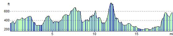
Elevation Profile