Hanslope Circular Ride
![]()
![]() A 20 mile circular cycle and walking route through open countryside in north Buckinghamshire.
A 20 mile circular cycle and walking route through open countryside in north Buckinghamshire.
It passes through a nature reserve and wildfowl centre on its way to a tour of the Saxon manors of Hanslope.
The open countryside of the Ouse and Tove Valleys gives extensive views across North Buckinghamshire and into Northants, with the distinctive spire of Hanslope Church the central feature.
The route is open to horseriders, pedal cyclists and walkers and uses a combination of metalled and unmetalled roads and tracks, and headland and crossfield bridleways. There are a number of gates to open and close and the bridleways can be muddy, particularly after wet weather.
The route is waymarked at every gate or major change in direction with a waymark disc - Circular Ride. Highlights on the route include the lovely Linford Lakes Nature Reserve where there are great wildlife spotting opportunities. You'll also pass the historic village of Great Linford where there's a fine manor house and several 17th century cottages to see.
Hanslope Circular Ride Ordnance Survey Map  - view and print off detailed OS map
Hanslope Circular Ride Open Street Map  - view and print off detailed map
Hanslope Circular Ride OS Map  - Mobile GPS OS Map with Location tracking
Hanslope Circular Ride Open Street Map  - Mobile GPS Map with Location tracking
Further Information and Other Local Ideas
The circular Cosgrove Canal Walk uses part of trail. The canalside village is well worth a visit with its 17th century pub and noteworthy early 19th century aqueduct to see.
For more walking ideas in the area see the Buckinghamshire Walks page.
Cycle Routes and Walking Routes Nearby
Photos

Almshouses, Great Linford. The almshouses at Great Linford built circa 1696.

Little Linford Wood. Little Linford Wood is now a nature reserve managed by the Berkshire, Buckinghamshire and Oxfordshire Wildlife Trust. It is one of the last remnants of a much larger Linford Wood, that is now either farmland, or the urban sprawl of Milton Keynes. The wood is home to a number of rare species, such as doormice and hornets.

Linford Lakes

A thatched house in Castlethorpe
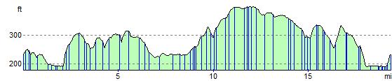
Elevation Profile