Hascombe Hill Walk

 This walk climbs to an Iron Age Hillfort and stone circle, near the village of Hascombe in the Surrey Hills.
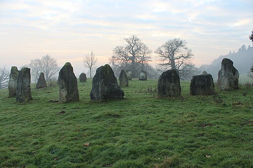
The walk starts from the attractive Hascombe village which lies just north of the hill. From here you can follow footpaths south through peaceful woodland to the hill top. Here you can explore the ancient fort and enjoy some fine views over the surrounding Surrey countryside. On the slopes of the hill there's also a photogenic stone circle built by the Megalithic Order of Druids in 1995/97.
The Greensand Way passes through the village so it's easy to continue your walking on this popular long distance path.
Please scroll down for the full list of walks near and around Hascombe. The detailed maps below also show a range of footpaths, bridleways and cycle paths in the area.
Postcode
GU8 4JA - Please note: Postcode may be approximate for some rural locationsHascombe Hill Ordnance Survey Map  - view and print off detailed OS map
Hascombe Hill Open Street Map  - view and print off detailed map
Hascombe Hill OS Map  - Mobile GPS OS Map with Location tracking
Hascombe Hill Open Street Map  - Mobile GPS Map with Location tracking
Walks near Hascombe
- Chiddingfold - This pretty Surrey based village is located in the Waverley area of the county
- Hydon's Ball and Hydon Heath - This National Trust owned hill is one of the high points of Surrey and a great place to stretch your legs
- Winkworth Arboretum - Enjoy a series of woodland walking trails in this beautiful arboretum in Godalming
- Hambledon - This rural Surrey village is surrounded by fields and woods with good walking trails to try
- Witley Common - This large area of common land in Surrey consists of heathland, ponds and birch, oak and pine woodland
- Thursley National Nature Reserve - This lovely nature reserve has miles of boardwalks and footpaths taking you to fine heathland, ponds, lakes and deciduous woodland
- Godalming - In the town there are many historic buildings with timer framed 16th century houses.
- Hankley Common - Explore this large area of heathland and pine woodland on this walk near Elstead in Surrey
Pubs/Cafes
After your walk you can enjoy refreshments at the White Horse. The old coaching inn dates to the 16th century and serves high quality dishes. There is also a lovely garden area for warmer days. You can find them at postcode GU8 4JA for your sat navs.
Photos
Hascombe Hill fort. The site was excavated in 1931 by S. E. Winbolt, who dated the occupation of the site to the 1st century BC. The hillfort encloses a thickly wooded area of approximately 2.4 hectares (6 acres). The sides of the fort, which are naturally very steep, were scarped at the top to make them almost unassailable. Encircling the crest of the hill is a defensive ditch 1.5 metres (5 ft) deep. The defences are reinforced on the northeast side (where the hillfort joins the rest of the hill) with a strong line of ramparts and ditches broken by a single entrance passage some 24 metres (80 ft) long.
Hascombe, Village Pond. The settlement contains a large cluster of cottages and country estates, St Peter's Church, the village green, a fountain, pond (pictured), a central public house and is surrounded by steep wooded hillsides.
View From Hascombe Hill. In the early 19th century the hill became an important naval telegraph station, using a mechanical form of semaphore to communicate with Netley Heath in Surrey on one side and Blackdown in Sussex on the other. A chain of such stations linked London with Portsmouth. The height of Hascombe Hill is 644 feet.


