Howden 20 Walk
![]()
![]() This 20 mile circular walk takes you on a tour of the countryside around the market town of Howden in Yorkshire.
This 20 mile circular walk takes you on a tour of the countryside around the market town of Howden in Yorkshire.
It starts and finishes in Howden next to the magnificent Howden Minster and follows the Rivers Ouse and Derwent through Boothferry, Wressle and Breighton. You then return to Howden along country lanes through Willitoft and Spaldington. You will also pass the interesting grade 1 listed Wressle Castle on the way.
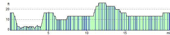
This is a fairly flat and easy walk with several long waterside sections to enjoy.
Howden 20 Ordnance Survey Map  - view and print off detailed OS map
Howden 20 Open Street Map  - view and print off detailed map
Howden 20 OS Map  - Mobile GPS OS Map with Location tracking
Howden 20 Open Street Map  - Mobile GPS Map with Location tracking
Walks near Howden
- Goole - The East Riding of Yorkshire town of Goole is located at the confluence of the rivers Don and Ouse and is the UK's furthest inland port, capable of handling nearly 2 million tonnes of cargo per annum
- Market Weighton Canal - Follow the Market Weighton Canal from the town of Market Weighton to the Humber Estuary on this waterside walk in the East Riding of Yorkshire.
Starting in the town centre follow the Weighton Beck south west for about 1.5 miles and you will join with the canal - Market Weighton Circular Walk - This circular walk around Market Weighton makes use of the Yorkshire Wolds Way to take you on a tour of the countryside, woodland, lakes and parkland surrounding the East Riding town
- Blacktoft Sands - Enjoy a circular walk around this pretty RSPB nature reserve
- Southfield Reservoir - This short walk visits Southfield Reservoir near Doncaster and Goole.
- North Cliffe Woods - This peaceful walk visits North Cliffe Woods in the East Riding of Yorkshire.
- North Cave Wetlands - This walk visits the North Cave Wetlands nature reserve in North Cave, East Riding of Yorkshire.
- Southfield Reservoir - This short walk visits Southfield Reservoir near Doncaster and Goole.
- Skipwith Common - This large open space near Selby has three colour coded, waymarked walks to try
- North Cliffe Woods - This peaceful walk visits North Cliffe Woods in the East Riding of Yorkshire.
- Bishop Wood - This walk explores the woodland trails in the expansive Bishop Wood near Selby, Cawood and Wistow.
- Bubwith Rail Trail - This walk takes you along the Bubwith Rail Trail from the village of Bubwith in East Riding of Yorkshire.
- Holme-on-Spalding-Moor - This large village in the East Riding of Yorkshire is located just to the west of Market Weighton.
Further Information and Other Local Ideas
To continue your walking around Howden you could head to neighbouring Goole and pick up the Trans Pennine Trail. The shared cycling and walking trail runs along the River Ouse before it joins with the River Humber near Brough.
Around Bubwith you can link up with the Bubwith Rail Trail. This flat, easy path will take you along an old railway line toward Holme-on-Spalding-Moor and Market Weighton.
Photos

The impressive tower at Howden Minster, seen from the churchyard. The manor and church at Howden were gifted to William of Calais (Bishop of Durham) in 1080 A.D. The original Norman church was rebuilt during the 13th century in the Early English style and again in the Decorated style in the mid 14th century. After being subjected to the Dissolution of Collegiate Churches and Chantries in 1548 the buildings were not destroyed, although some parts were allowed to fall into disrepair as only the nave was used for services. The Parliamentarians are said to have used parts of the Minster as a stable during the English Civil War. The chancel roof collapsed in 1696 and the chapter house roof in 1750. The church was further damaged by a fire in 1932 apparently started by drunks attending the town's horse fair, and was restored once again in 1934. The chapter house received a new roof in 1984 and other ruined elements are now designated a safe ruin, preserved by the Department of the Environment.

Howden Marsh. The eastern end of the lake at Howden Marsh Nature Reserve. Seventeen acres of Howden Marsh have been leased by Howden Town Council from the local authority (now the East Riding of Yorkshire Council) since 1974. The site was designated a Local Nature Reserve in May 2002.

Pump Brickyard Farm North Howden. This small 'windmill' was almost certainly a wind pump used to drain the former clay pits which are now fishing lakes. The clay would have been used for brick making for the local building industry, which is where Brickyard Farm gets its name. The pump is only about fifty metres east of Wood Lane and not where there is a windmill shown on the O/S maps.
.jpg)
Loftsome Bridge over the River Derwent, south of Wressle, East Riding of Yorkshire. Walkers can be seen on the grassy riverside path in the photo.

The River Ouse, Boothferry. Looking west over a gate on the Trans Pennine Trail. Here the outflow at Knedlington Clough joins the River Ouse. The trail runs along the floodbank of the river. The gatepost sports signs for the Trans Pennine Trail, a public footpath, and the Howden Twenty.

River Derwent near Gunby. The river flows towards Gunby Ings, and away from the photographer. Footpaths run along this eastern side of the river at least as far as Bubwith, and with a junction taking you onto the Bubwith Rail Trail.

Wressle Castle. Looking north-northeast across the River Derwent at dusk. The Wressle Castle ruins were once part of a larger building begun in around 1380 by Sir Thomas Percy, brother of the Earl of Northumberland. Thomas Percy lost his head for siding with his brother Henry Percy who led a rebel army against King Henry IV at the Battle of Shrewsbury in 1403. The castle was later occupied by parliamentary forces during the English Civil War, and in 1648 they dismantled most of the building leaving two corner towers and one of the four ranges which connected them. What remained of the castle was occupied until 1796 when it was gutted by a fire. There is currently no general public access to Wressle Castle which is situated on a working farm owned by the Falkingham family.

River Derwent, South Duffield Ings, north of Wressle.. Looking east-southeast across the river from the embankment off the eastern end of Holmes House Lane, towards a pond on the west side of Breighton Road, Wressle.
Elevation Profile