John Ray Walk
![]()
![]() Travel along the John Ray Walk from Braintree to Witham on this lovely walk through Essex. You will pass through the delightful countryside of the Brain Valley,
the birthplace and home of John Ray.
Travel along the John Ray Walk from Braintree to Witham on this lovely walk through Essex. You will pass through the delightful countryside of the Brain Valley,
the birthplace and home of John Ray.
Heralded as the father of English natural history he had a supreme understanding of the natural world. One of Ray's greatest achievements was to lay the foundations for the classification of all living things.
At the end of the route you could try the Witham River Walk which continues south along the River Brain to the Whetmead Nature Reserve.
John Ray Walk Ordnance Survey Map  - view and print off detailed OS map
John Ray Walk Open Street Map  - view and print off detailed map
John Ray Walk OS Map  - Mobile GPS OS Map with Location tracking
John Ray Walk Open Street Map  - Mobile GPS Map with Location tracking
Further Information and Other Local Ideas
Just to the south of Witham is the pleasant neighbouring village of Wickham Bishops where you'll find an ancient 11th century church and an unusual old wooden railway viaduct.
Cycle Routes and Walking Routes Nearby
Photos

Footpath junction on the John Ray walk. John Ray is sometimes called the father of British natural history. He was born at nearby Black Notley in 1627.

Cowslips and waymarker post on the trail near Silver End. It was John Ray who coined the trems pollen and petal.

John Ray Cottage, Black Notley, Essex. This was the home of the famous botanist, John Ray, who was born here on 29th November 1627.
.jpg)
River Witham entering South Witham

Black Notley Hall

Footpath through the fields near White Notley.

Footpath & Rivenhall Thicks. This is the footpath from Silver End to Whitham the wood in the background is Rivenhall Thicks

This is the footpath from Whitehead Farm to Temple Lane
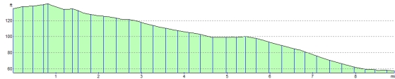
Elevation Profile