Jubilee Way
![]()
![]() Follow the Jubilee Way from Old Sodbury to the Severn Bridge on this delightful walk.
Follow the Jubilee Way from Old Sodbury to the Severn Bridge on this delightful walk.
The path heads towards Thornbury before entering the Severn Vale and passing through Hay Wood. You then follow the Severn Estuary to the finish point at the landmark bridge.
The Cotswold Hills provide a splendid backdrop for much of the walk.
Jubilee Way Ordnance Survey Map  - view and print off detailed OS map
Jubilee Way Open Street Map  - view and print off detailed map
Jubilee Way OS Map  - Mobile GPS OS Map with Location tracking
Jubilee Way Open Street Map  - Mobile GPS Map with Location tracking
Further Information and Other Local Ideas
At Old Sodbury you can pick up the Frome Valley Walkway. This will take you along the River Frome to Bristol, passing the historic Snuff Mills and the historic village of Winterbourne on the way. At the other end of the route you can pick up the Severn Way and visit Oldbury on Severn.
For more walking ideas in the area see the Gloucestershire Walks and Somerset Walks pages.
Cycle Routes and Walking Routes Nearby
Photos

Cotswold Lane, Old Sodbury

Ashbys, Tytherington. Grade II listed dovecote with a datestone of 1810.

Millennium Wood, Rangeworthy The parish council recently arranged to plant a Millennium Wood in a field north of the Recreation ground, where the allotments used to be. Court View cottage is being extended.

The Severn Suspension Bridge
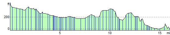
Elevation Profile