Kingswinford Railway Walk
![]()
![]() A circular walk from Kingswinford along a disused railway track, visiting Wombourne and the Staffordshire and Worcestershire Canal.
A circular walk from Kingswinford along a disused railway track, visiting Wombourne and the Staffordshire and Worcestershire Canal.
The walk starts just to the north of the town where you can pick up the South Staffordshire Railway Walk. This shared cycling and walking trail follows the trackbed of the old Wolverhampton to Dudley railway line. Follow the flat path west and it will take you to Himley and the woodland of the Himley Plantation. The trail then heads through Wombourne where this route leaves the rail trail to cross Bratch Bridge. You can continue all the way along the rail trail to Wolverhampton though if you wish.
This route heads to the impressive Bratch Locks on the canal. Here you can pick up the towpath and follow it south to Swindon. You then leave the canal to head back to Himley where you can pick up the South Staffordshire Railway Walk and return to the start point near Kingswinford.
Kingswinford Railway Walk Ordnance Survey Map  - view and print off detailed OS map
Kingswinford Railway Walk Open Street Map  - view and print off detailed map
Kingswinford Railway Walk OS Map  - Mobile GPS OS Map with Location tracking
Kingswinford Railway Walk Open Street Map  - Mobile GPS Map with Location tracking
Pubs/Cafes
One popular pit stop for people on the route is the railway cafe in Wombourne. The cafe is set in restored railway station and offers a delicious selection of freshly made food, breakfast, lunch and afternoon tea. If the weather is good you can sit outside in the garden or under cover on the platform.
Further Information and Other Local Ideas
To continue your walking in the area head south along the canal on the Kinver Canal Walk and then climb to the popular Kinver Edge for great views over the area.
To the south of the town you can also pick up the Stourbridge Canal and enjoy another easy waterside stroll.
To the east you can explore the woodland sculpture trails in the wildlife rich Saltwells Nature Reserve. You will also find the pretty Netherton Reservoir and the Dudley Canal in this area. The canal lies at the southern end of the Victorian Netherton Tunnel. With a torch you can walk through the pitch black tunnel to Dudley Port at the other end.
Just to the north there's the 18th century Himley Hall. The historic hall is surrounded by ‘Capability’ Brown landscaped parkland with woodland walks, waterfalls and a large lake.
For more walking ideas in the area see the West Midlands Walks page.
Cycle Routes and Walking Routes Nearby
Photos
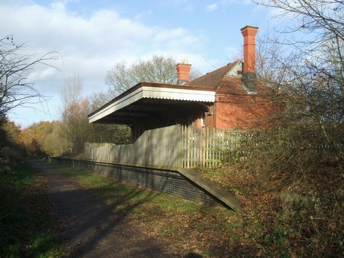
Kingswinford Railway Walk, West Midlands. The railway was finally closed in 1965 , having only served passengers for seven years from 1925 to 1932.
Himley Station, Staffordshire With astonishing optimism, the Great Western Railway opened this station in 1925 with a platform more than 140 metres in length! Passengers used the line for just seven years. Now it part of the South Staffordshire Railway Walk


