Lightwater Country Park
![]()
![]() This park is located in Camberley, Surrey, and comprises 145 acres of heathland habitat, woodland, shrubs and lowland bog. These habitats offer the opportunity to observe a wide variety of wildlife, birds, mammals, plants and insects. There are a number of fine walking trails in the park, an on site car park and an excellent visitor centre with a wealth of information.
This park is located in Camberley, Surrey, and comprises 145 acres of heathland habitat, woodland, shrubs and lowland bog. These habitats offer the opportunity to observe a wide variety of wildlife, birds, mammals, plants and insects. There are a number of fine walking trails in the park, an on site car park and an excellent visitor centre with a wealth of information.
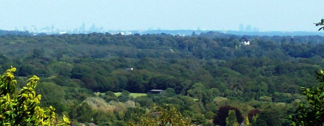
At the western side of the park there are also some nice hill climbs with excellent views towards London and Guildford. There is also an MOD vehicle testing track in this area so take care they are not testing when you walk in this area.
Postcode
GU18 5RG - Please note: Postcode may be approximate for some rural locationsLightwater Country Park Ordnance Survey Map  - view and print off detailed OS map
Lightwater Country Park Open Street Map  - view and print off detailed map
Lightwater Country Park OS Map  - Mobile GPS OS Map with Location tracking
Lightwater Country Park Open Street Map  - Mobile GPS Map with Location tracking
Pubs/Cafes
There's a good on site cafe selling a good range of sandwiches and snacks. Inside there's also information panels about the Heathland habitats in the park. There's some outside picnic areas where you can sit and enjoy views of the park if the sun is shining.
Dog Walking
The woodland and parkland trails are ideal for dog walking so you'll probably see plenty of other owners on a fine weekend day. The cafe mentioned above is also dog friendly.
Further Information and Other Local Ideas
Just to the east of the park there's more nice trails around Windlesham Arboretum. There's peaceful woodland with follies, rare trees, a lake and lake house to see. You can find them a short walk from the park at postcode GU19 5PA.
Lightwater Park is located near the Camberley Walk where you can visit Swinley Forest, Bracknell Forest and the Tri Lakes Country Park. There's miles of good woodland and waterside trails on this splendid route.
Just to the north you could pick up the Bagshot Park Walk. This takes you past the noteworthy royal residence to the pretty Rapley Lake. The Grade II listed house has been country home of Prince Edward and Sophie Wessex since their 1999 wedding.
For more walking ideas in the area see the Surrey Walks page.
Cycle Routes and Walking Routes Nearby
Photos
Bridleway to Heatherside Corner. The white-painted tree trunks show the route across the MOD's vehicle testing tracks.
The London Skyline. This view was taken from the summit of White Hill and the tower buildings forming the London skyline can be clearly seen. I believe Canary Wharf is the complex on the right.


