Llanidloes Walks
![]()
![]() Llanidloes is nicely positioned for walking with waymarked trails eminating from the town in all directions. As such you are spoilt for choice with so much lovely scenery to explore.
Llanidloes is nicely positioned for walking with waymarked trails eminating from the town in all directions. As such you are spoilt for choice with so much lovely scenery to explore.
This circular walk makes use of the Severn Way long distance trail to explore the countryside to the west of the town. There's nice views of the River Severn and the River Dulas which also runs through the little town.
Starting in the centre of town follow the waymarked path south west along Penygreen Road. You'll then cross the Severn on the Felindre Bridge and head north west past Felindre Mill. The country lane takes you along the river to Bronfelen where you turn south along a bridleway. You can then follow a nice scenic country lane past Caencoed and back into the town.
There's several other good options for extending your walking in the area. You could pick up the epic Glyndwr's Way and follow it north west to visit the beautiful Llyn Clywedog. The lake is a great place for birdwatching and also includes a spectacular dam which is the tallest concrete dam in the UK.
Also of interest are the peaceful woodland trails in nearby Hafren Forest and the Sarn Sabrina Walk which runs around the town.
Llanidloes Ordnance Survey Map  - view and print off detailed OS map
Llanidloes Open Street Map  - view and print off detailed map
Llanidloes OS Map  - Mobile GPS OS Map with Location tracking
Llanidloes Open Street Map  - Mobile GPS Map with Location tracking
Walks near Llanidloes
- Severn Way - Follow the River Severn from its source at Plynlimon in Powys, to Bristol, the mouth of the river
- Llyn Clywedog - The scenery surrounding this large reservoir near Llanidloes is truly wonderful
- Glyndwr's Way - Starting at Knighton on the English/Welsh border follow this wonderful 135 mile long trail through some of the most stunning landscape in Wales
- Hafren Forest - This large woodland area near Llanidloes has miles of walking paths and mountain bike trails to try
- Sarn Sabrina Walk - This stunning circular walk explores the area around the town of Llanidloes in Powys
- Dylife Waterfall Walk - This circular walk visits the wonderful Ffrwd Fawr waterfall from the village of Dylife in Powys
- Glaslyn Nature Reserve - This circular walk visits a tranquil nature reserve and lake in the Cambrian Mountains of Wales.
Pubs/Cafes
There's a few nice pubs in the town where you can enjoy some refreshments after your walk. One of the highlights is the historic Angel Inn. The Timber framed former Coaching Inn was built way back in 1748. The Pub has a wealth of Character with many original features including Oak beams in the Bar and Lounge. There's a very good menu and some picnic tables outdoors for warmer days. It is located close to the center of Llanidloes on the High Street with a postcode of SY18 6BY for your sat navs.
Further Information and Other Local Ideas
The town is located close to the Cambrian Mountains where there are more fabulous walking opportunities including the climb to Plynlimon - the highest point in the range.
Follow the Glyndwr's Way north for a few miles and you will soon come to Dylife where you can pick up the circular Dylife Waterfall Walk. This explores a wonderful gorge with spectacular views to the Ffrwd Fawr waterfall.
Photos
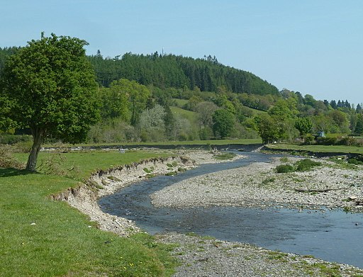
Severn valley west of Llanidloes. A couple of miles west the town the Severn flood plain starts to widen out, and the initial enthusiasm of the river calms down. The river is hidden in the trees in the valley floor (obviously). The steep hillside to the left (north) is Pen y Banc.
Former mill at Llanidloes, now converted into apartments. The River Severn has just been joined by Afon Dulas and is becoming a sizeable but shallow river.
The half-timbered Old Market Hall stands at the crossroads of the four streets of the original medieval town. Built around 1600, it is the only surviving building of this type in Wales. Assize courts were held in the hall around 1605, and John Wesley preached from a pulpit stone on the open ground floor in 1748.


