Cambrian Mountains Walks

This wonderful area of mid Wales has challenging hill climbs, several stunning lakes and numerous pretty towns and villages to explore.
Use the links to view full route information including elevation profiles, interactive maps and GPS downloads.
You can also view an overview map of all the routes in the using the Cambrian Mountains Walk Map>>
*New* - Walks and Cycle Routes Near Me Map - Waymarked Routes and Mountain Bike Trails>>
| Route Name | Photo | Distance | Description |
| Cambrian Way | 297.6 miles (479 km) | This epic long distance trail runs from Cardiff on the south coast of Wales to Conwy on the north coast. View Full Details>> | |
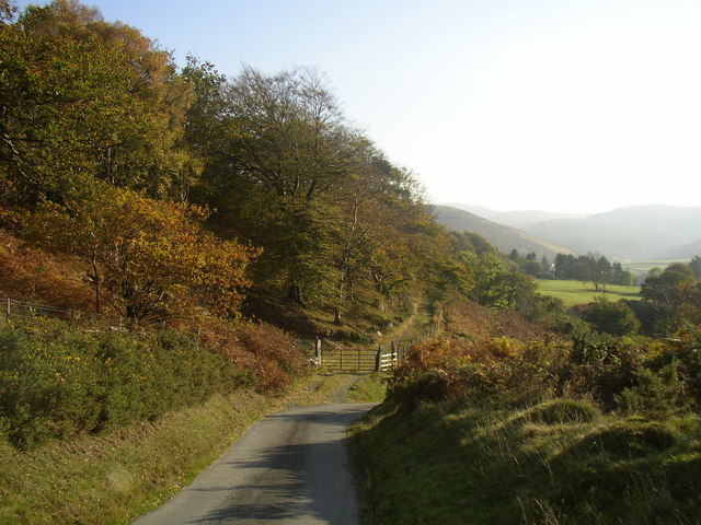
| Claerwen Reservoir | 11.2 miles (18 km) | Enjoy a cycle or walk along this large reservoir in the Cambrian Mountains. There is a good track running along the northern shore of the lake which makes for a nice traffic free cycle or walk. It runs for about 6 miles starting at the Claerwen Dam car park. There are lovely views across the water to the surrounding hills and countryside. If you would like to extend your exercise in the area then you could visit the other reservoirs in the Elan Valley by heading south along the River Claerwen to Caban Coch Reservoir where you can pick up the climb to Drygarn Fawr and other cycling and walking trails. You could also try the Teifi Pools Walk which starts from the nearby Strata Florida Abbey near Pontrhydfendigaid. View Full Details>> | |
| Devil's Staircase | 5.6 miles (9 km) | This walk or cycle takes you to the Devil's Staircase in Powys, Wales. View Full Details>> | |
| Drygarn Fawr | 7.2 miles (11.6 km) | This walk climbs to Drygarn Fawr in Powys. You can start the walk from the car park at the Caban Coch Reservoir, part of the Elan Valley Reservoirs. View Full Details>> | |
| Dylife Waterfall Walk | 5.3 miles (8.6 km) | This circular walk visits the wonderful Ffrwd Fawr waterfall from the village of Dylife in Powys. View Full Details>> | |
| Elan Valley Reservoirs | 10.6 miles (17 km) | This waterside cycling and walking route takes you through the beautiful Elan Valley in Powys. View Full Details>> | |
| Glaslyn Nature Reserve | 1.3 miles (2.1 km) | This circular walk visits a tranquil nature reserve and lake in the Cambrian Mountains of Wales. View Full Details>> | |
| Glyndwr's Way | 134.8 miles (217 km) | Starting at Knighton on the English/Welsh border follow this wonderful 135 mile long trail through some of the most stunning landscape in Wales. Highlights on the route include rolling Welsh Hills, views of the River Severn, a series of interesting Welsh towns, several beautiful waterfalls including the Rhiwargor Waterfall and the lovely lakes of Llyn Clywedog and Lake Vyrnwy. View Full Details>> | |
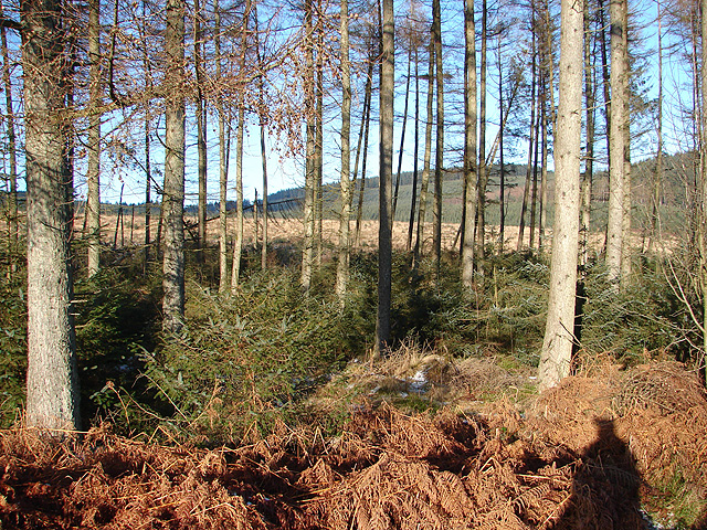
| Hafren Forest | 3.7 miles (6 km) | This large woodland area near Llanidloes has miles of walking paths and mountain bike trails to try. In the forest you will find the source of the River Severn, pretty waterfalls and a wide variety of wildlife. Look out for ospreys, buzzards, goshawks and red kites on your way through the woods. You can start your exercise from the Hafren Forest car park. Here you'll find an information point, toilets and a picnic area. It's located near the centre of the forest and gives direct access to the trails. The long distance Severn Way passes through the forest so you can pick this up to extend your walk. If you head north west along the path through the woods you will come to the start of the trail at the Source of the River Severn on the slopes of Plynlimon. If you follow the trail south east it will take you into Llanidloes. You could also head east and visit the nearby Llyn Clywedog. The large lake has nice cycling and walking trails including the long distance Glyndwr's Way which runs along the western side of the water. The lake can be found on the eastern fringe of the forest. View Full Details>> | |
| Llandovery | 3.7 miles (6 km) | This market town in the Cambrian Mountains has some nice riverside walks along the River Towy and River Bran to try. This circular walk takes you along the river before exploring the woodland and countryside to the south of the town. View Full Details>> | |
| Llandrindod Wells | 5 miles (8 km) | This circular walk takes you around the victorian spa town of Llandrindod Wells in the Cambrian Mountains. View Full Details>> | |
| Llanidloes | 7.1 miles (11.5 km) | Llanidloes is nicely positioned for walking with waymarked trails eminating from the town in all directions. As such you are spoilt for choice with so much lovely scenery to explore. This circular walk makes use of the Severn Way long distance trail to explore the countryside to the west of the town. There's nice views of the River Severn and the River Dulas which also runs through the little town. Starting in the centre of town follow the waymarked path south west along Penygreen Road. You'll then cross the Severn on the Felindre Bridge and head north west past Felindre Mill. The country lane takes you along the river to Bronfelen where you turn south along a bridleway. You can then follow a nice scenic country lane past Caencoed and back into the town. View Full Details>> | |
| Llyn Brianne | 13.7 miles (22 km) | Enjoy a walk or cycle along this beautiful reservoir in central Wales. The reservoir sits at the head of the River Towy with a dam 299 feet high and 951 feet long. There's a lovely country lane running along the eastern side of the water. It climbs high above the reservoir with wonderful views over the water to the surrounding countryside and hills. The lane is ideal for a quiet cycle ride in beautiful surroundings. The route starts from the car park at the southern end of the water and follows the track through the Tywi Forest before finishing at the bridge at the northern end of the reservoir. Look out for red squirrels as you pass through the forest. You can view the scenery and follow the route using the google street view link below. To extend your walking in the area you could head to the Gwenffrwd-dinas RSPB Nature Reserve which is just to the south of the reservoir. Here you can enjoy great views of the River Towy and look out for red kites and a variety of butterflies. Just to the north west of the lake you will find Soar y mynydd a Calvinist Methodist Church sitting in the valley of the river Camddwr in the Cambrian Mountains. It's claim to fame is that it is the remotest chapel in all Wales. To the north east of the lake you will find the village of Abergwesyn, Vicarage Meadows and the pretty Nant Irfon National Nature Reserve. There's some nice woodland trails here with lots of bluebells in the spring. View Full Details>> | |
| Llyn Clywedog | 4.3 miles (7 km) | The scenery surrounding this large reservoir near Llanidloes is truly wonderful. This walk takes you along the western side of the reservoir along the Glyndwr's Way long distance footpath. You start at the car park at south western end of the water with views of the Afon Clywedog. You then head past the spectacular dam which is the tallest concrete dam in the UK, with a height of 72 metres and a length of 230 metres. The walk continues to the north western edge of the reservoir with a mixture of lakeside sections and woodland trails. It's a splendid area for bird watching too. Look out for ospreys, red kites, buzzards and ravens on your walk. The whole of this route is designed for walkers but cyclists can enjoy the second half of the route where there is a splendid trail along the lakeside. For the first half you can follow country lanes to the west of the lake. If you would like to continue your walking in the area you could continue along the Glyndwr's Way or the Sabrina Way into the adjacent Hafren Forest. View Full Details>> | |
| Machynlleth | 5 miles (8 km) | This market town in Powys has some lovely trails to try through the Dovey and Lllyfnant Valleys. This walk takes you through the latter valley with riverside paths, woodland trails and a visit to the Cors Dyfi Nature Reserve near Derwenlas. Machynlleth is significant as the ancient capital and parliamentary seat of wales, home to Laura Ashley and lying within the UNESCO Dyfi Biosphere reserve. The walk starts just to the west of the town at the visitor centre. From here you can pick up country lanes heading south to Wylfa. Woodland trails then continue south taking you into the Lllyfnant Valley where you can enjoy riverside footpaths. The trails then bend round to the Cors Dyfi Nature Reserve in Derwenlas. The site includes habitats such as open water, swamp, bog, wet woodland, scrub and gorse. Boardwalks will take you to viewing platforms where you can look out for wildlife including Ospreys, otters, red kites, peregrines and hen harriers. View Full Details>> | |
| Nant-y-moch Reservoir | 9.9 miles (16 km) | Enjoy a walk along this beautiful reservoir in the Cambrian Mountains. It's a very peaceful place with fine views across the water to the surrounding hills and mountains. The reservoir dates from 1964 and forms part of the Cwm Rheidol hydroelectric power scheme. The headwaters of the reservoir include the source of the River Rheidol. You can start the walk from the car park next to the dam on the southern side of the water. From here you can pick up a quiet lane running west along the lake. You can follow this round to the northern side of the water where there are some hill climbs with fine views back down to the reservoir. These paths can also take you past Drosgol hill. View Full Details>> | |
| Pistyll Y Llyn Waterfall Walk | 4.2 miles (6.7 km) | This walk visits the Pistyll Y Llyn Waterfall in the Cambrian Mountains. View Full Details>> | |
| Plynlimon | 5 miles (8 km) | Climb to the highest point in the Cambrian Mountains on this challenging circular walk in Ceredigion. There are wonderful views of the reservoirs, countryside and forests of mid-wales to enjoy. The walk starts from the parking area on the A44 at Esteddfa Gurig. You then pass a farm and then through a gate marked 'All Walks' before beginning the ascent. The path takes you to the summit of Pen Pumlumon Fawr which stands at a height of 752 metres (2,467 ft). Here you will find a trig point and magnificent views in all directions. You can then descend the same way or via Pen Y Drawsallt, to the west. View Full Details>> | |
| Rhayader | 5.3 miles (8.5 km) | This mid Wales town in the Cambrian Mountains has some lovely walking through the Wye and Elan Valleys. Rhayader is the first town on the banks of the River Wye, 20 miles (32 km) from its source on the Plynlimon range of the Cambrian Mountains. The Wye Valley Walk long distance trail passes through the town and is a great way of exploring the area. This circular walk makes use of the trail to climb to a viewpoint south of the town before enjoying an easy riverside stroll at the end. The walk starts in the town and heads south along the waymarked trail to Glan-Elan and the Glyn Bridge where you cross the river. The trail then climbs through a pretty nature reserve towards Bwlch Goch. This section is quite steep and you will reach a height of over 1200ft. You'll be rewarded with fine views over the surrounding countryside though. The route then descends back to the Glyn Bridge which you cross again. Head north east from here and you can follow woodland paths back to the river, before a final riverside stretch takes you back into the town centre. View Full Details>> | |
| Sarn Sabrina Walk | 24.9 miles (40 km) | This stunning circular walk explores the area around the town of Llanidloes in Powys. You begin at Llanidloes and pass along the beautiful Llyn Clywedog with its large dam, before climbing into the Cambrian mountains, where you will arrive at the highest point of the range at Plynlimon. Here you will find the source of the River Severn - the longest river in Britain, marked with a post in both English and Welsh. The route then returns to Llanidloes, passing through Hafren Forest, before joining the River Severn for a long waterside section that leads you to the finish point of the walk. The walk is named after the Celtic myth of Sabrina, a water nymph said to inhabit the waters of the River Severn. View Full Details>> | |
| Source of the River Severn | 6.2 miles (10 km) | This walk visits the Source of the River Severn from Hafren Forest along a section of the Severn Way. The source can be found high on Plynlimon, in the uplands of Mid-Wales, on the western boundaries of the forest. View Full Details>> | |
| Teifi Pools | 9.3 miles (15 km) | This splendid circular walk in the Cambrian Mountains takes you around a series of beautiful lakes. The lakes of Llyn Teifi, Llyn Hir, Llyn Gorlan, and Llyn Egnant are collectively known as the Teifi Pools. A footpath starts from the car park at the Strata Florida Abbey near Tregaron and Pontrhydfendigaid in the county of Ceredigion. The former Cistercian abbey was originally founded in 1164. You can explore the ruins which include a largely in tact main entrance archway. The 9 mile walk then follows country lanes and footpaths to the lakes. It is quite a challenging walk as you must climb up to the lakes which are in a elevated position of about 1400ft. You'll climb to Cwm Teifi before heading around and between the lakes. The route then descends past Graig Wen and Nant Egnant to the abbey car park. It's a challenging route but you are rewarded with wonderful views over the Cambrian Mountains and the lovely countryside of the River Teifi Valley. You can see the route start point of the abbey ruins and car park on the google street view link below! If you enjoy this walk then you could head to the nearby Claerwen Reservoir and follow the waterside cycle and walking track along the lake. View Full Details>> | |
| Tywi Valley | 4.1 miles (6.6 km) | This walk explores the Tywi Valley and forest in the Cambrian Mountains. View Full Details>> |