Long Man of Wilmington
![]()
![]() Climb to this iconic hill figure on Windover Hill on this splendid circular walk in the South Downs. The walk begins in the village of Alfriston on the Cuckmere River and follows the South Downs Way to the Long Man. It's a fairly easy climb on a good path with splendid views of the South Downs and the coast to enjoy. From the high point you descend to Litlington passing the delightful Lullington Heath Nature Reserve on the way. It's a lovely area made up of chalk heath with heather, bell heather and gorse bushes. At Litlington you pick up the Vanguard Way and enjoy a lovely waterside section along the Cuckmere River which takes you back to Alfriston.
Climb to this iconic hill figure on Windover Hill on this splendid circular walk in the South Downs. The walk begins in the village of Alfriston on the Cuckmere River and follows the South Downs Way to the Long Man. It's a fairly easy climb on a good path with splendid views of the South Downs and the coast to enjoy. From the high point you descend to Litlington passing the delightful Lullington Heath Nature Reserve on the way. It's a lovely area made up of chalk heath with heather, bell heather and gorse bushes. At Litlington you pick up the Vanguard Way and enjoy a lovely waterside section along the Cuckmere River which takes you back to Alfriston.
If you enjoy this walk then you could try the Cuckmere River and Cuckmere Haven walk which also starts from Alfriston.
Postcode
BN26 5TL - Please note: Postcode may be approximate for some rural locationsLong Man of Wilmington Ordnance Survey Map  - view and print off detailed OS map
Long Man of Wilmington Open Street Map  - view and print off detailed map
Long Man of Wilmington OS Map  - Mobile GPS OS Map with Location tracking
Long Man of Wilmington Open Street Map  - Mobile GPS Map with Location tracking
Explore the Area with Google Street View 
Pubs/Cafes
Back in Alfriston you could try the The George Inn. The historic pub dates all the way back to the 14th century and has a charming interior with low beams and a roaring fire. Outside there's a lovely beer garden to relax in on warmer days. You can find the pub on the High Street at a postcode of BN26 5SY for your sat navs. The pub is also dog friendly if you have your canine friend with you.
If you're doing the walk from Wilmington you could head to The Giant’s Rest in the village. The country pub does good food, is dog friendly and also has a beer garden. You can find it at postcode BN26 5SQ.
Further Information and Other Local Ideas
For a shorter walk you can climb to the hill from Wilmington. The little village is located less than a mile from the figure and has a public car park next to Wilmington Priory.
Cycle Routes and Walking Routes Nearby
Photos
.jpg)
Good view of Long Man on a sunny summer day

The ancient hill figure viewed from Milton Street in the village of Wilmington

Viewed from the footpath from Wilmington at sunset. The first record of a chalk figure dates from 1710 and the 226 foot figure has been scaled in a way so as not to look short and stumpy from below. Whether the figure dates back to antiquity has been much debated but is generally believed not to. The figure is in the current ownership of the Sussex Archeological Society who received it from the Duke of Devonshire along with nearby Wilmington Priory in 1926.

Ruins of Wilmington Priory. Founded for the abbey of Grestain in Normandy before 1100, a large proportion of the present building dates from the fourteenth century. The village makes and alternative start point for a shorter route to the summit

Wilmington Village. The village is located just north of the Long Man.

Footpath, Wilmington Hill. Making its way through the remains of Neolithic flint mines before descending the hill in a north easterly direction. The village of Wilmington can be seen in the top right of the picture.

Wilmington Chalk Pit

The South Downs Way, Windover Hill
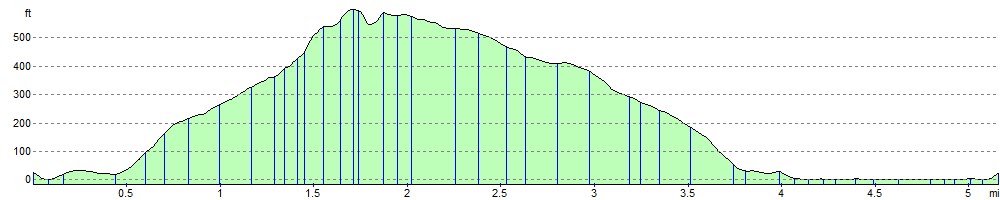
Elevation Profile