Vanguard Way
![]()
![]() This 66 mile trail runs from the outskirts of London, through Ashdown Forest, Alfriston and Cuckmere Valley to the stunning East Sussex coast.
This 66 mile trail runs from the outskirts of London, through Ashdown Forest, Alfriston and Cuckmere Valley to the stunning East Sussex coast.
Route highlights include the lovely Ashdown Forest, the White Horse near Alfriston and the wonderful final coastal stretch that gives views of the Seven Sisters Cliffs and Tidemills beach. The path also passes through the beautiful Cuckmere Valley with splendid views of Cuckmere River and Cuckmere Haven to enjoy.
Please click here for more information.
Vanguard Way Ordnance Survey Map  - view and print off detailed OS map
Vanguard Way Open Street Map  - view and print off detailed map
Vanguard Way OS Map  - Mobile GPS OS Map with Location tracking
Vanguard Way Open Street Map  - Mobile GPS Map with Location tracking
Pubs/Cafes
Near Hailsham, on the eastern side of Arlington Reservoir you'll find the noteworthy Old Oak Inn. This 18th Century oak beam traditional English pub has a good menu and selection of drinks. There's also a splendid garden area where you can sit out and enjoy lunch on fine days. Large family tables for 8 offer outside seating for up to 150 persons with views of the countryside and the adjacent Abbot's Wood. It's the ideal spot to relax in when the sun is shining. You can find the pub in the little village of Arlington on the western fringes of the woods. The postcode for your sat navs is BN26 6SJ.
Further Information and Other Local Ideas
Also near Hailsham you will find one of the notable local attractions at Michelham Priory at Upper Dicker. This former Augustine Priory dates from the 13th century and includes some original buildings which are Grade I and Grade II listed. It's a very pretty site with a watermill in the grounds of the priory which has been restored to working order and is open to the public. The historic site is located just to the east of the route near Arlington Reservoir. It's well worthy of some investigation if you have time to take a small detour.


Above:Michelham Priory views. An idyllic setting with with the lovely pond and house on the right.
Cycle Routes and Walking Routes Nearby
Photos

Stile on Vanguard Way. Looking south towards the Mill House and pond where the Wealdway meets the Vanguard Way. The small stream known as Tickerage feeds the pond.

Taken from the footbridge over an un-named stream south of Hammerwood.
Photo taken in the spring of 2008.

Looking south after leaving Pound Lane, the Vanguard Way path crosses open fields then down to the Tickeridge stream.

The footpath and the trees in the foreground are all within the gridsquare. The high ground on the horizon is part of the Ashdown Forest.

Looking toward a junction of embankments with the two long distance footpaths heading to the left towards Tide Mills and Newhaven where the Vanguard Way ends after travelling down from Croydon and the Ouse Valley Way really only begins (if heading upstream) on its 42 mile journey to Lower Beeding.

The long distance footpath follows the course of the bridleway from Berwick before turning south down the drive to Stonery Farm which is behind the hedge to the right.

The route includes the cliff top walk from Seaford to Cuckmere Haven. This area includes the Seaford Head Nature Reserve which includes a variety of flora and fauna with some spectacular views of the Cuckmere valley.

The Vanguard Way near Gills Lap in Ashdown Forest
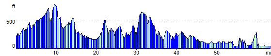
Elevation Profile