Maelor Way
![]()
![]() This splendid walk takes you from the Shropshire/Cheshire border into Wales.
This splendid walk takes you from the Shropshire/Cheshire border into Wales.
The path starts at Grindley Brook near Whitchurch and heads west to Penley in Wales, passing around the pretty Hanmer Mere on the way. You continue to Overton and then Erbistock where you join the River Dee and then the River Ceiriog to Chirk before the final waterside section leads to the finish point at Bronygarth.
This is a beautiful walk through some fabulous English and Welsh countryside. It also has several waterside streches along the two rivers with a stroll along the Llangollen Canal near Chirk to enjoy also.
Please click here for more information
Maelor Way Ordnance Survey Map  - view and print off detailed OS map
Maelor Way Open Street Map  - view and print off detailed map
Maelor Way OS Map  - Mobile GPS OS Map with Location tracking
Maelor Way Open Street Map  - Mobile GPS Map with Location tracking
Pubs/Cafes
The route passes through the little village of Hanmer where you can stop off at the splendid Hanmer Arms. The 16th century inn has an attractive interior with wood burning stoves and authentic pub decor. There's also a lovely garden area where you can go for a stroll afterwards. You can find them at postcode SY13 3DE for your sat navs. They are dog friendly if you have your canine friend with you. Just to the south of the pub you'll also find the pretty Hanmer Mere, part of Shropshire's Lake District.
In Erbistock there's The Boat Inn to consider. The riverside building dates back to the 1600s and is known for its association with the old ferry and as part of the collection of buildings which form the Erbistock conservation area.
They serve high quality dishes which you can enjoy in the lovely outdoor seating area overlooking the River Dee.
Postcode for sat navs is LL13 0DL.
Cycle Routes and Walking Routes Nearby
Photos

Maelor Way and Iscoyd Wood

Plas-yn-y-coed farm Close to the Wales / England border, this farm is just in Shropshire, the Afon Dyfrdwy which is the border is in the woodland behind the buildings. The Llwybr Maelor Way footpath skirts around the farm buildings.

Bronington - view across valley to Sandholes Bronington - view from the trail to Sandholes and across the Wych Valley to Wigland and Agden on the north (Cheshire) side.
_join_-_geograph.org.uk_-_842360.jpg)
Wych Brook - three counties (and two countries) join Bronington (Wales) / Whitchurch (Shropshire) / Agden (Cheshire). Looking upstream along Wych Brook from the footbridge at its confluence with Red Brook to form Grindley Brook. This is the junction of Wales, Shropshire and Cheshire.

Agden - the last house in Cheshire Agden - on Oldhall Street (B5395) just west of its junction with the A41 trunk road. Last house in Cheshire. Shropshire (Whitchurch) lies over Grindley Brook (bridge in middle distance).

Bronington. View across valley to Higher Wych Bronington (Kiln Green) - view from the Maelor Way as it passes along the lane near Maes-y-Groes Farm - across the valley of Wych Brook towards Higher Wych on the far (Cheshire) slope.
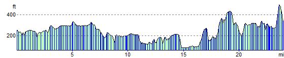
Elevation Profile