Mid Suffolk Footpath

 This footpath runs from Hoxne to Stowmarket through the Suffolk countryside. The route passes Eye, Thorndon and Mendlesham before finishing just outside Stowmarket.
Highlights on the path are the town of Eye with its ruined castle, and waterside sections along the Rivers Dove and Gipping.
This route links with the Gipping Valley River Path which takes you along the river to Needham Market and the pretty Needham Lake.
Mid Suffolk Footpath Ordnance Survey Map  - view and print off detailed OS map
Mid Suffolk Footpath Open Street Map  - view and print off detailed map
Mid Suffolk Footpath OS Map  - Mobile GPS OS Map with Location tracking
Mid Suffolk Footpath Open Street Map  - Mobile GPS Map with Location tracking
Pubs/Cafes
The historic Queens Head in Eye is a good choice for a pit stop. The ancient pub dates back to 1590 and boasts mediaeval beams, open fires and a fine garden for warmer days. The garden was originally part of the industrial area of Eye which flourished as a major market town until Diss overtook as the regional centre with the introduction of the railway. The serve good quality food and have an extensive selection of drinks. The pub is located in the heart of the town on Cross Street at postcode IP23 7AB for your sat navs. They are dog friendly if you have your canine friend with you.
In Stowupland The Crown is worthy of some consideration. It is an historic thatched pub dating to the 14th century. They serve good food and can be found at postcode IP14 4BQ. They have a car park, garden and area also dog friendly. The village is also a pretty place with several village greens having been awarded the Suffolk "Village of the Year" prize in 2006.
Further Information and Other Local Ideas
Just off the route near Eye, is the noteworthy village of Thornham Magna where you can try the Thornham Walks on the old Thornham Estate. The estate is a great place for easy walks with pleasant woodland trails and a particularly lovely walled garden.
Cycle Routes and Walking Routes Nearby
Photos

Hoxne Watermill

Church and Guildhall, Eye. Taken from the ruins of Eye castle

Manor Farmhouse, Thorndon, Suffolk

Mendlesham Green

Old Market Street timber framed black and white buildings, Mendlesham. Some lovely characterful properties in this village.

Bury Street, Stowmarket

Stowupland village sign. Just east of Stowmarket.
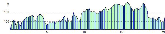
Elevation Profile