Mynydd Mawr
![]()
![]() Climb to the 698 m (2,290 ft) summit Mynydd Mawr on this challenging climb in the Snowdonia National Park. On the walk you will enjoy stunning views of Llyn Cwellyn and the surrounding mountains. The walk starts from the village of Rhyd Ddu and follows woodland trails through Beddgelert Forest before climbing above Llyn Cwellyn to Foel Rudd and then on to the Mynydd Mawr summit. There are interesting geological formations, rocky outcrops and breathtakingly beautiful views to enjoy. It's also a fairly quiet walk with most people heading to Snowdon from Rhyd Ddu.
Climb to the 698 m (2,290 ft) summit Mynydd Mawr on this challenging climb in the Snowdonia National Park. On the walk you will enjoy stunning views of Llyn Cwellyn and the surrounding mountains. The walk starts from the village of Rhyd Ddu and follows woodland trails through Beddgelert Forest before climbing above Llyn Cwellyn to Foel Rudd and then on to the Mynydd Mawr summit. There are interesting geological formations, rocky outcrops and breathtakingly beautiful views to enjoy. It's also a fairly quiet walk with most people heading to Snowdon from Rhyd Ddu.
If you'd like to continue your climbing in the area then the Snowdon Rhyd Ddu Path starts from the village too. You could also head along the wonderful Nantlle Ridge.
Mynydd Mawr Ordnance Survey Map  - view and print off detailed OS map
Mynydd Mawr Open Street Map  - view and print off detailed map
Mynydd Mawr OS Map  - Mobile GPS OS Map with Location tracking
Mynydd Mawr Open Street Map  - Mobile GPS Map with Location tracking
Further Information and Other Local Ideas
Just to the west you can explore the Dorothea Quarry where you'll find the remains of the old mining houses and a series of scenic lakes including Llyn Nantlle Uchaf. The quarry is one of the significant sites on the Snowdonia Slate Trail which runs through the area. The circular long distance trail can be used to visit several of the other historic mining areas located in the World Heritage Site. Heading north along the trail would take you to Dinorwic Quarry which was at one time the second largest slate quarry in the world. The quarry is located on the edge of Padarn Country Park where there are some lovely waterside trails along Llyn Padarn and Llyn Peris.
The Lon Gwyrfai multi user path skirts the eastern edge of the forest. The trail runs between Rhyd Ddu and Beddgelert along a nice easy surfaced path.
For more walking ideas in the area see the Snowdonia Walks page.
Cycle Routes and Walking Routes Nearby
Photos

View of Mynydd Mawr. Seen from the Rhyd-ddu - Nantlle road

The Nantlle Ridge Range from Mynydd Mawr Summit 1. The summits of Y Garn, Mynydd Drws-y-coed and Mynydd Tal-y-mignedd dominate the skyline.

Nantlle Ridge from Mynydd Mawr Summit 2. A South-southeasterly view.

Summit Cairn. The summit cairn of Mynydd Mawr looking northwest towards Foel Goch and Moel Cynghorion on the Moel Eilio Ridge. The stoney summit area is scattered with numerous cairns and shelters of all sizes.

Craig y Bera Gulley. A southerly view through a rocky gulley in Craig y Bera to the Dyffryn Nantlle valley floor below.

Cwm Planwydd Valley. The Afon Goch in the Cwm Planwydd valley descends to Llyn Cwellyn below with the Moel Eilio range forming the background of the photo.

Drws y Coed from Craig y Bera. A southerly view through a gulley from the top of Craig y Bera at grid reference SH 54367 54218 to Drws-y-Coed in the Dyffryn Nantlle Valley below.

Llyn Cwellyn and the Moel Eilio Ridge, near to Betws Garmon, Gwynedd, Great Britain. A northeastern view of Llyn Cwellyn and the entire Moel Eilio Ridge taken from near the summit of Foel Rudd.
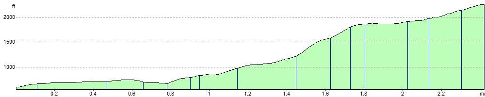
Elevation Profile