North Berwyn Way
![]()
![]() This challenging walk explores the North Berwyn Mountains, to the south of the River Dee, in Denbighshire.
This challenging walk explores the North Berwyn Mountains, to the south of the River Dee, in Denbighshire.
The route starts in Llangollen and heads west to Corwen, passing Ceiriog Forest and Cynwyd before a final waterside section along the River Dee takes you to Corwen.
The area of the Berwyn Mountains is wild and covered in thick heather with some acidic grassland and bracken. The views of North Wales from the peaks are spectacular.
The walk is waymarked with a blue and white disc.
Please click here for more information
North Berwyn Way Ordnance Survey Map  - view and print off detailed OS map
North Berwyn Way Open Street Map  - view and print off detailed map
North Berwyn Way OS Map  - Mobile GPS OS Map with Location tracking
North Berwyn Way Open Street Map  - Mobile GPS Map with Location tracking
Pubs/Cafes
At the start/finish point in Corwen the Crown Hotel is worthy of some investigation. The historic inn dates all the way back to 1628. The interior is full of olde worlde character with interesting features including pewter tankards hanging from the ceiling. They serve good food and are designated as a Camra Welsh Heritage pub. There's also a snooker table upstairs. You can find them on Bridge Street at postcode LL21 0AH.
Further Information and Other Local Ideas
To the south of the trail you can visit the villages of Glyn Ceiriog and Llanarmon Dyffryn Ceiriog where you can explore the beautiful Upper Ceiriog Valley.
Around Corwen you can pick up the Dee Valley Way which runs to Llangollen on waymarked paths.
The Llangollen Round and Llangollen Canal can also be picked up nearby.
Cycle Routes and Walking Routes Nearby
Photos

Part of the North Berwyn Way ascends out of the Dee Valley

Launched the day before this photo was taken in 2007, the North Berwyn Way, is a 15-mile trail that can be walked from Llangollen or Corwen, and links the villages of Carrog and Glyndyfrdwy, and the Llangollen Steam Railway. The North Berwyn is a site of Special Scientific Interest, and Special Area of Conservation, and walkers and bird enthusiasts may see rare birds like merlins, peregrine falcons, hen harriers, or black grouse. This section is just south of Carrog near Llidiart-y-Parc.

Berwyn mountains View north from the top of Pistyll Rhaeadr. Nant y Llyn runs down the valley opposite. The path on the right leads to Cadair Berwyn.

View from footpath down into Llangollen. The Llwybr Gogledd y Berwyn (North Berwyn Way) uses the footpath to gain access to a bridlepath further up the hill. This is a typical walk out of Llangollen which is in a steep sided valley.

Follow straight from the strainer. This major fencing project is putting a new fence along the Sir Ddinbych/Wrecsam border which is presumably a border of land ownership as well. The heather has been cut back to make working easier, and of course, has provided a great walking space along the trail.

The Way follows the fence line towards Vivod Mountain resulting in the turn to the left.

An open access track leading up the hill and onto the trail. This is also used as a green lane for motor cycles and vehicles.

View back down the trail to the Dee valley
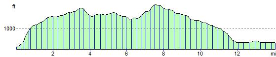
Elevation Profile