GPS Cycle and Walking Routes

Polzeath to Port Isaac Walk

9 miles (14.2 km)

This walk follows a popular section of the South West Coast Path from Polzeath to Port Isaac on the Cornish coast.
The walk runs for just under 9 miles along an undulating cliff top path with wonderful views throughout. It's a great area for marine wildlife with dolphins and grey seals to look out for as you make your way along the path.
The walk starts from the beach front car park at Polzeath, overlooking Hayle Bay. Follow the waymarked trail north and it will take you around the headland to Pentire Point and Sandinway Beach.
You continue east along Port Quin Bay to Carnweather Point and Port Quin.
The final section takes you past Kellan Head and Varley Head before finishing in Port Isaac.

Polzeath to Port Isaac Walk OS Map - Mobile GPS OS Map with Location tracking

Polzeath to Port Isaac Walk Open Street Map - Mobile GPS Map with Location tracking

Photos

Polzeath - geograph.org.uk - 2281678

Polzeath. The tourist village has a sandy beach and is popular with holiday-makers and surfers. It's also good for wildlife with Dolphins sometimes seen in the bay and the coastline north of the village. Bird species you can see include corn buntings and puffins.

The Goose and Pentire Point East - geograph.org.uk - 2507625

The Goose and Pentire Point East. Pentire Point headland is located just north east of Polzeath near the start of the walk. The headland and peninsula cover an area of about one mile square. Pentire Point and Stepper Point stand at either side of the mouth of the River Camel estuary (Pentire to the north-east, Stepper to the south-west). The coastline around the headland is owned by the National Trust, although the bulk of the headland itself is let to Pentire Farm. The headland is a Site of Special Scientific Interest, designated for its geology and flora and fauna including nationally rare plants. Look out for grey seals in this area.

Com Head and Pengirt Cove - geograph.org.uk - 226072

Com Head and Pengirt Cove. Taken from the Coastal Footpath this shows the deep drop down to Pengirt Cove and then Com Head and in the distance an island called The Mouls. No fencing along this stretch and long drops down to the sea. At the base of these cliffs are a number of old mine shafts

The Coastal Slope Looking Towards Carnweather Point - geograph.org.uk - 2281602

Carnweather Point.

Port Quin - geograph.org.uk - 2391529

Port Quin. This photogenic cove gives its name to Port Quin Bay, a 2.5 mile stretch of coast that extends from Kellan Head to The Rumps. During the medieval period boats from Port Quin often sailed to Wales trading coal, manure, antimony, lead and building ashlar.  A few small fields around the hamlet are owned by the National Trust for Places of Historic Interest or Natural Beauty; the Trust rents out several of the stone cottages as self-catering holiday accommodation.
Various locations around Port Quin were used in the 1970s by the BBC for filming an adaptation of Winston Graham's Poldark novels. 

Kellan Head viewed from Doyden - geograph.org.uk - 1290775

Kellan Head

Varley Head - geograph.org.uk - 310376

Varley Head. In the distance across the bay are the cliffs around Tintagel.

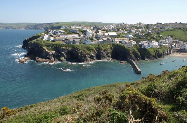
Port Isaac - geograph.org.uk - 2391259

Port Isaac. The village centre dates from the 18th and 19th centuries, from a time when its prosperity was tied to local coastal freight and fishing.  Since 2004, the village has served as the backdrop to the ITV television series Doc Martin.

Video

GPS Files

GPX File

Polzeath to Port Isaac Walk.gpx (On Desktop:Right Click>'Save As. On Ipad/Iphone:Click and hold>Share>Save to Files')