Walk Around Ramsbottom
![]()
![]() A circular walk around Ramsbottom visiting some of the highlights of the area including River Irwell, Nuttall Park, Holcombe and the iconic Peel Tower.
A circular walk around Ramsbottom visiting some of the highlights of the area including River Irwell, Nuttall Park, Holcombe and the iconic Peel Tower.
The walk starts from the train station and heads a short distance to the east to pick up the Irwell Sculpture Trail. Follow the path south and you will soon come to Nuttall Park where there's nice views of the surrounding hills, tree lined footpaths, river views and a series of sculptures.
After exploring the park you continue south along the river to Brooksbottoms. Here you turn west to follow woodland trails towards Hazelhurst where you start to climb towards Peel Tower.
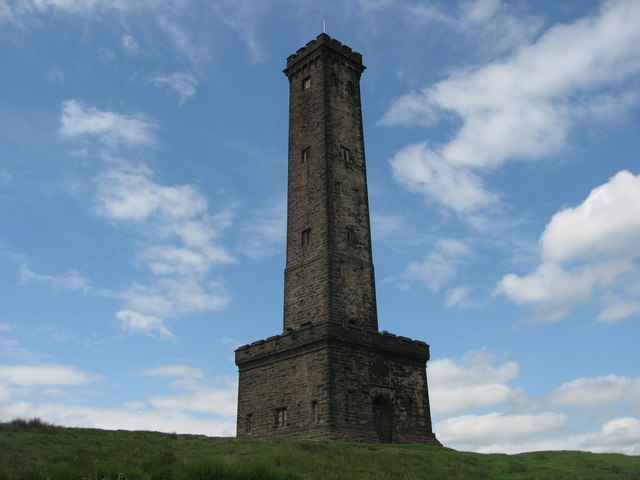
The tower is a popular local landmark dedicated to Sir†Robert Peel, the 19th century Prime Minister considered the father of modern†British policing. There's great views over Ramsbottom, Greater Manchester and North Wales from the summit on Holcombe Hill.
The route then descends from the tower to Holcombe where you follow minor roads back to the train station.
To continue your walking in the Ramsbottom area, head south along the Irwell Sculpture Trail to nearby Bury. On the way you'll pass the historic old mills, heritage railway station and impressive viaduct at Summerseat before heading to Burrs Country Park. Here you'll find woodland, open space, wetland, ponds and waterways.
In Bury there's some nice easy trails to follow around the pretty Elton Reservoir. Entwistle Reservoir and Wayoh Reservoir lie just to the west too.
Postcode
BL0 0DL - Please note: Postcode may be approximate for some rural locationsRamsbottom Ordnance Survey Map  - view and print off detailed OS map
Ramsbottom Open Street Map  - view and print off detailed map
*New* - Walks and Cycle Routes Near Me Map - Waymarked Routes and Mountain Bike Trails>>
Ramsbottom OS Map  - Mobile GPS OS Map with Location tracking
Ramsbottom Open Street Map  - Mobile GPS Map with Location tracking
Pubs/Cafes
The Eagle and Child in Ramsbottom is a pub worthy of some investigation. It was named Great British Pub Awards ‘Pub of the Year’ in September 2017 and has a whole host of other awards to its name. It's a pub with a social conscience targeting young people who are marginalised and need extra help such as young offenders and disabled young people. They're rated as one of the best food pubs in Greater Manchester, having consistently featured in all the main national newspapers ‘Top 50 Sunday Lunch’ features. One of the main attractions is a stunning Orangery dining room, with fine views across the Irwell valley to Holcombe. The expansive garden area includes an outdoor kitchen and bar, polytunnel, veg beds, compost beds, fruit shrubs and ornamental beds and a mini orchard with chickens. It's a lovely setting and the ideal place to round off your walk. You can find the pub in the town on Whalley Rd with a postcode of BL0 0DL for your sat navs.
Dog Walking
The park and river trails make for a fine dog walk. The Eagle and Child mentioned above is also dog friendly.
Further Information and Other Local Ideas
Head north along the river and you can visit the Lancashire town of Rawtenstall, another stop on the East Lancs Railway. There's also the excellent Whitaker Museum and Art Gallery to visit here. On the way you would pass the worthy village of Irwell Vale with its views of the River Ogden and historic terraced mill cottages and gothic church.
On the southern outskirts of the town there's some peaceful and serene woodland trails around Redisher Wood. In the woods there are also water features including the Holcombe Brook, a picturesque lake and waterfalls.
Just to the east you can enjoy waterside paths around Ashworth Moor Reservoir before visiting the old mill ruins in the pretty Cheesden Valley.
For more walking ideas in the area see the Greater Manchester Walks page.
Cycle Routes and Walking Routes Nearby
Photos
Nuttall Park Footbridge. The original Nuttall road bridge,that crossed over the river Irwell at this point, was a bridge that carried the local traffic (probably horse and carts in those days). It collapsed in 1928 and was replaced by just a footbridge.
Peel Tower. The 128 ft Peel Tower is a memorial to Sir Robert Peel the founder of the modern police force as we know it today. The tower occupies a prominent position on Holcombe Hill 1100 feet (335 metres) above sea level. A public subscription provided the £1,000 needed to build the tower in 1852.


