Rough Tor
![]()
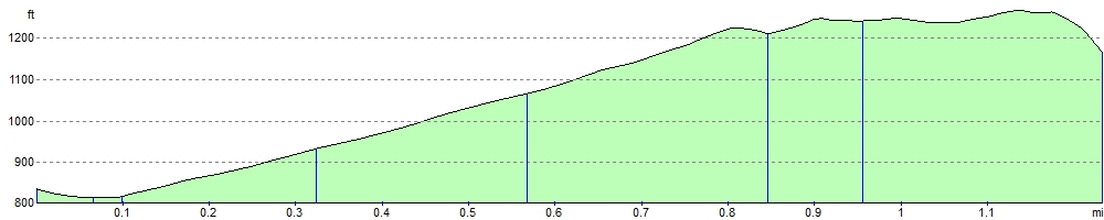
![]() This is a climb to the 1313 ft (400m) summit of Rough Tor on Bodmin Moor. Rough Tor is the second highest point in Cornwall and a popular spot for walkers.
This is a climb to the 1313 ft (400m) summit of Rough Tor on Bodmin Moor. Rough Tor is the second highest point in Cornwall and a popular spot for walkers.
The walk starts from the car park at the end of Rough Tor Road which leads out of Camelford. You then climb across a wide slope of Access Land on the moor to the striking granite tor. There are super views from the summit over the moor and surrounding countryside. The area has a fascinating Neolithic and Bronze age history with numerous cairns and burial monuments in the vicinity.
You can extend your walk easily by visiting the nearby Showery Tor and climbing up to Brown Willy - the highest point on the moor.
You could also visit Crowdy Reservoir. There's nice views across the water, woodland trails in Davidstow Woods and lots of wildlife to look out for on the lake. Around here you can also pick up the long distance Copper Trail. The epic trail takes you to many of the scenic highlights on the moor and several historic Cornish Copper mines.
Postcode
PL32 9QJ - Please note: Postcode may be approximate for some rural locationsRough Tor Ordnance Survey Map  - view and print off detailed OS map
Rough Tor Open Street Map  - view and print off detailed map
Rough Tor OS Map  - Mobile GPS OS Map with Location tracking
Rough Tor Open Street Map  - Mobile GPS Map with Location tracking
Explore the Area with Google Street View 
Pubs/Cafes
Head west into nearby Camelford and there's a few good refreshment options. The Masons Arms does good food and has a lovely garden area to sit in when the weather is good. The interior is full of character with a ceiling full of old bottles, mugs, cups, tankards and old newspaper clippings. You can find the pub in the market place at a postcode of PL32 9PB for your sat navs. The Camelford Way long distance footpath can also be picked up in the town. The trail explores the River Camel Valley to the south of the riverside settlement.
Dog Walking
The area is great for dog walking. The Masons Arms pub mentioned above is also dog friendly.
Further Information and Other Local Ideas
For more walking ideas in the area see the Bodmin Moor Walks page.
Cycle Routes and Walking Routes Nearby
Photos

Rough Tor. Stannon china clay works in the distance.

Looking west from the moorland below Rough Tor, the quarry of the china clay workings at Edenvale.

Bridge over stream close to Crowdy reservoir

Valley bottom north of Roughtor

Showery Tor. On the NE end of the Rough Tor Ridge

WW2 Memorial to the 43rd Wessex Division, Summit of Rough Tor, Bodmin Moor, Cornwall. A brass plaque on the summit. Brown Willy in the background.

Cairn on Little Rough Tor

Granite boulders on the northern slopes of Rough Tor. Flooded china clay workings can be seen in the distance.
Elevation Profile