St Pauls Cray Circular Walk
![]()
![]() A short circular walk around St Paul's Cray in Bromley. The route takes you through Pauls Cray Hill Park, past Cray Valley Golf Club and through Park Wood where you will pass the Scadbury Park Nature Reserve. Good access points are the parking lot at Park Wood or St Mary Cray Station.
A short circular walk around St Paul's Cray in Bromley. The route takes you through Pauls Cray Hill Park, past Cray Valley Golf Club and through Park Wood where you will pass the Scadbury Park Nature Reserve. Good access points are the parking lot at Park Wood or St Mary Cray Station.
This is quite an easy walk with the main highlight the section through Scadbury Park. With 300 acres of ancient woodland and the ruins of the Elizabethan Moated Manor House it is well worth exploring.
Just to the east of St Pauls Cray the route also crosses the Cray Riverway. This pleasant waterside walk will take you south along the River Cray to the source at Orpington or north to Erith where it meets the River Darent and the Thames.
St Pauls Cray Circular Walk Ordnance Survey Map  - view and print off detailed OS map
St Pauls Cray Circular Walk Open Street Map  - view and print off detailed map
St Pauls Cray Circular Walk OS Map  - Mobile GPS OS Map with Location tracking
St Pauls Cray Circular Walk Open Street Map  - Mobile GPS Map with Location tracking
Further Information and Other Local Ideas
Just to the west there's the Chislehurst Walk and the Petts Wood Circular Walk to try. The epic London Loop can be picked up here and used to further explore the area.
For more walking ideas in the area see the London Walks page.
Cycle Routes and Walking Routes Nearby
Photos
.jpg)
The Bull Inn, St. Pauls Cray
.jpg)
K6 Telephone Kiosk, St Pauls Cray

Paul's Cray Hill Park

Scadbury Park, Chislehurst
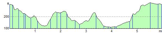
Elevation Profile