London Loop
![]()
![]() Also known as the London Outer Orbital Path, this walk takes you on a tour of the parks, woods and fields around the edge of Outer London. You start at Erith, on the River Thames and pass through Crayford, Orpington, Petts Wood, Coulsdon, Kingston upon Thames, Uxbridge, Elstree, Cockfosters, Chingford, Epping Forest, Upminster and Rainham Marshes RSPB before finishing back on the River Thames at Purfleet, opposite Erith.
Also known as the London Outer Orbital Path, this walk takes you on a tour of the parks, woods and fields around the edge of Outer London. You start at Erith, on the River Thames and pass through Crayford, Orpington, Petts Wood, Coulsdon, Kingston upon Thames, Uxbridge, Elstree, Cockfosters, Chingford, Epping Forest, Upminster and Rainham Marshes RSPB before finishing back on the River Thames at Purfleet, opposite Erith.
The walk has been divided into 24 manageable sections as follows:
Erith
Old Bexley
Petts Wood
West Wickham Common
Hamsey Green
Coulsdon South
Banstead Downs
Ewell
Kingston Bridge
Hatton Cross
Hayes
Uxbridge
Harefield
Moor Park
Hatch End
Elstree
Cockfosters
Enfield Lock
Chingford
Chigwell
Havering-atte-Bower
Harold Wood
Upminster Bridge
Rainham
On the way you'll also pass numerous parks, common land and open spaces such as High Elms Country Park in Orpington, Hayes Common, Stanmore Common, Harrow Weald Common and Nonsuch Park.
The walk is waymarked with a disc featuring a kestrel.
London Loop Ordnance Survey Map  - view and print off detailed OS map
London Loop Open Street Map  - view and print off detailed map
London Loop OS Map  - Mobile GPS OS Map with Location tracking
London Loop Open Street Map  - Mobile GPS Map with Location tracking
Pubs/Cafes
On the walk stop at the Fox Inn in Bromley for refreshments (postcode: BR2 6BQ). The pub sits next to Keston Common and includes a nice large beer garden to relax in during the summer months here.
At Addington Hills we recommend The Surprise Inn located a short distance from the park on Upper Shirley Rd, Croydon. It's a very nice pub/restaurant with a great menu and a nice outdoor seating area. You can find it at postcode CR0 5HF for your sat navs.
Further Information and Other Local Ideas
For more walking ideas in and around the capital see the London Walks page.
Cycle Routes and Walking Routes Nearby
Photos
_-_geograph.org.uk_-_1357469.jpg)
To the right of picture are the offices at Canary Wharf, some 9 miles away. Towards the left of picture, the tops of the offices in the City of London can just be seen above the skyline; also 9 miles away. On the extreme left of picture is one of the television transmitters at Crystal Palace, a mere 4 miles away.

Gardens at High Elms Country Park

Nonsuch Mansion, Nonsuch Park, Surrey. Parts of the present mansion date from the 18th century but the greater part, including the south front and the state rooms, were built 1802 - 6 for Samuel Farmer. The architect was Jeffey Wyatt (later Sir Jeffery Wyattville) who also worked on Windsor Castle.

Banstead Downs

Queen Elizabeth's Hunting Lodge, Chingford. This Grade II listed former hunting lodge, is now a museum, on the edge of Epping Forest. It was built in 1543 for King Henry VIII and now provides an insight into the Tudor history of the forest. It's well worth exploring with the additonal bonus of some lovely views over the forest from the top floor of the building.

New River Loop, Enfield. Looking towards Trinity Church, as seen from the bridge at River View.

Grand Union Canal in South Harefield. This is the Broad Water reach of the canal, upstream of Wide Water lock. The towpath forms part of the London Loop and is also the route of National Cycle Network 61.

Oxhey Woods section of the trail. This footpath through Oxhey Woods is in Section 14 between Moor Park and Hatch End. It is marked with solid red diamonds on the Ordnance Survey's 1:50,000 scale mapping and by solid green ones on the 1:25,000 scale.
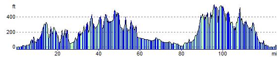
Elevation Profile