Torpel Way
![]()
![]() This walk runs from Peterborough to Stamford through countryside and agricultural land. The path passes Marholm, Helpston and Barnack before finishing with a riverside stretch along the River Welland into Stamford.
This walk runs from Peterborough to Stamford through countryside and agricultural land. The path passes Marholm, Helpston and Barnack before finishing with a riverside stretch along the River Welland into Stamford.
In Stamford you can extend your walk by visiting Burghley House. Head south from the trail to explore the stunning Capability Brown landscaped grounds.
Torpel Way Ordnance Survey Map  - view and print off detailed OS map
Torpel Way Open Street Map  - view and print off detailed map
Torpel Way OS Map  - Mobile GPS OS Map with Location tracking
Torpel Way Open Street Map  - Mobile GPS Map with Location tracking
Pubs/Cafes
In Barnack there's the Millstone pub for a pit stop. It's an historic pub of some note, dating to 1672. They have bistro dining and a beautiful courtyard with it’s own outside bar. You can find them at a postcode of PE9 3ET for your sat navs.
Further Information and Other Local Ideas
In Barnack you could take a small detour from the route to visit the Barnack Hills And Holes National Nature Reserve. There's a rather interesting and unusual landscape here with grassy undulating slopes in an ancient medieval quarry. The site is noted for some signficant flora and fauna as well. You can find the reserve on the western side of Barnack village near Stamford. Postcode for sat navs is PE9 3EU.
Cycle Routes and Walking Routes Nearby
Photos

The fields towards Bainton from the Torpel Way

The Torpel Way crossing a stream north of Barnack

River Welland upstream from Uffington Bridge

Embankment along River Welland

The site of Uffington and Barnack station from the Torpel Way

The Way heads away from Barnack

Ford on the River Welland

A view of the waymarked posts you will soon along the route.
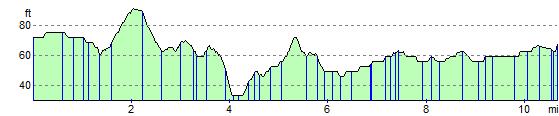
Elevation Profile