Two Rivers Way
![]()
![]() Starting on Congresbury Bridge over the River Yeo follow the Two Rivers Way through Somerset to Keynsham on the River Avon. The walk passes through Wrington, Chew Stoke, Chew Magna, Compton Dando and Pensford with sections along the River Yeo and River Chew to enjoy.
Starting on Congresbury Bridge over the River Yeo follow the Two Rivers Way through Somerset to Keynsham on the River Avon. The walk passes through Wrington, Chew Stoke, Chew Magna, Compton Dando and Pensford with sections along the River Yeo and River Chew to enjoy.
Other highlights on the route include the Stanton Drew Stones which include the Great Circle - the second largest stone circle in Britain (after Avebury Stones). You'll also pass the lovely Chew Valley Lake which has delightful nature trails and a variety of wildlife. Near here there's also the photogenic Pensford Viaduct which is a Grade II listed building, spanning the River Chew near the attractive village of the same name. All the way there's splendid views of the Mendip Hills AONB and the Somerset countryside.
Two Rivers Way Ordnance Survey Map  - view and print off detailed OS map
Two Rivers Way Open Street Map  - view and print off detailed map
Two Rivers Way OS Map  - Mobile GPS OS Map with Location tracking
Two Rivers Way Open Street Map  - Mobile GPS Map with Location tracking
Pubs/Cafes
In Wrington there's the Plough Inn. There's a charming old world interior with oak beams and well stocked bar. Outside there's extensive front and back gardens and a Boules Pitch. You can find them on the High Street at postcode BS40 5QA for your sat navs.
Further Information and Other Local Ideas
For more walking ideas in the area see the Somerset Walks and the Mendip Hills Walks pages.
Cycle Routes and Walking Routes Nearby
Photos

Millennium Bridge, Congresbury at the start of the walk. This pedestrian bridge which spans the river Yeo links the main part of the village to the Congresbury Millennium Green. The bridge and green formed part of the village's marking of the year 2000 celebrations.

West of Stanton Drew. This path links the Avon at Keynsham to the Yeo at Congresbury making a pleasant walk across North Somerset countryside. The B&B on the left is well placed!

Approaching Woollard. On the Two Rivers Way, heading up the Chew valley. The new bridge can just be seen on the left.

Passing Chew Court in Chew Magna. The Way follows a footpath along the east side of the grounds of the court, which is "said to have been one of the country residences of the Bishops of Bath and Wells" and is of "C14/C15 origin"

Publow, Chew Valley

Northern-most edge of Chew Valley Lake

Stanton Drew standing stones

Pensford Viaduct This railway viaduct at Pensford makes a theatrical entrance for the footpath to the Chew Valley and the Stone Circles at Stanton Drew.
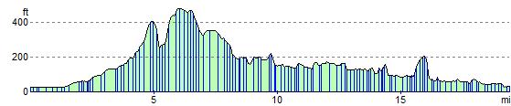
Elevation Profile