Waun Fach Walk
![]()
![]() Climb to the highest mountain in the Black Mountains on this challenging walk in the Brecon Beacons. The walk starts from Castell Dinas just of the A479.
Climb to the highest mountain in the Black Mountains on this challenging walk in the Brecon Beacons. The walk starts from Castell Dinas just of the A479.
This Iron Age hillfort has the highest castle in England and Wales. There is also a car park which makes a good start point for the climb to Waun Fach. From here you follow bridleways past Rhyd-y-car farm before turning south past a series of cairns. The final section turns east to take you to the 811 m (2,661 ft) summit. Here you can enjoy views over the Brecon Beacons including Rhos Fawr and the Radnor Forest. You may also see some wild ponies wandering around the area.
You could also start the walk from the nearby town of Talgarth. The village is located just a few miles north of Castell Dinas.
For a longer, more challenging route to the summit try the Dragons Back circular walk. This starts from Pengenffordd and visits Y Grib and Pen Y Manllwyn before climbing to the Waun Fach summit.
To further extend your walking in the area you could head to the nearby Grwyne Fawr Reservoir and Mynydd Du Forest where there are miles of walking trails and mountain bike trails to try.
Postcode
LD3 0EW - Please note: Postcode may be approximate for some rural locationsWaun Fach Ordnance Survey Map  - view and print off detailed OS map
Waun Fach Open Street Map  - view and print off detailed map
*New* - Walks and Cycle Routes Near Me Map - Waymarked Routes and Mountain Bike Trails>>
Waun Fach OS Map  - Mobile GPS OS Map with Location tracking
Waun Fach Open Street Map  - Mobile GPS Map with Location tracking
Further Information and Other Local Ideas
For a longer circular horseshoe walk to the summit see the video below.
To the west is the climb to Mynydd Troed and Cockit Hill from Pengenffordd.
In nearby Talgarth there's ancient woodland and waterfalls to see in the Pwll-y-Wrach Nature Reserve. There's also some interesting local history with an 18th century watermill and the 11th century Bronllys Castle to visit.
Cycle Routes and Walking Routes Nearby
Photos

Castell Dinas. The mounds on the right are the remains of what appears to have been the central keep of this former fortress. They now form the highest point of the hill at around 1500ft above sea level. The spot affords magnificent views to the Wye valley to the north and down that of the Rhiangoll to the south - something which would presumably have been of some interest to its one-time occupants. Views east along the 'Dragon's Back' to the high point of the Black Mountains at Waun Fach and west to Mynydd Troed are another good reason for making the short ascent to this summit.

On Mynydd Llysiau

View south from Pen Trumau

Summit Cairn, Pen Trumau

Cairn beside the path up Pen Trumau towards Waun Fach

The Vale of Grwyney

View north-west from Waun Fach

Waun Fach Summit. In the far distance the conical shape of Sugar Loaf mountain.
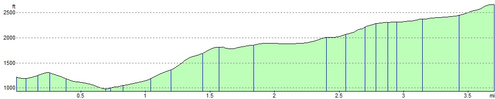
Elevation Profile